







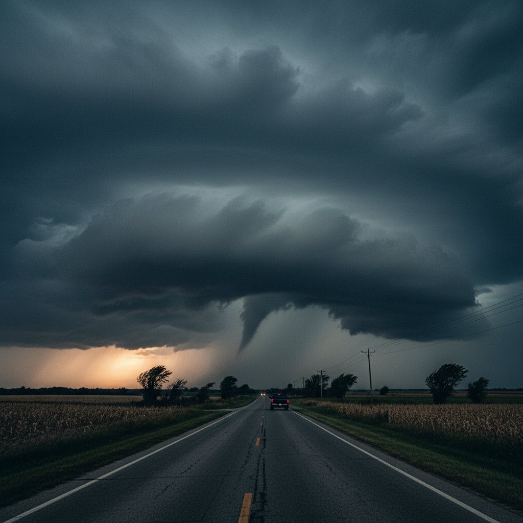
On June 10, 2026, a dramatic wall cloud descended over the rural landscapes of Kirksville and LaPlata, Missouri, offering a stark reminder of nature’s raw power. Captured in a series of striking photographs by local storm chasers, the cloud formation stretched across the horizon, its rotating base a telltale sign of potential severe weather. The images, which quickly circulated on social media, show a menacing, low-hanging cloud structure that meteorologists later confirmed was a precursor to a brief but intense thunderstorm.
The wall cloud, a localized lowering of a storm’s base, is often the first visual cue that a tornado may form. In this case, the storm produced no confirmed tornadoes, but it did unleash damaging winds and heavy rainfall across Adair County. For residents of Kirksville, a town of about 17,000, the sight was both awe-inspiring and unsettling. ‘I’ve lived here my whole life, and I’ve never seen anything like it,’ said local farmer Mark Thompson, who snapped a photo from his porch. ‘The sky just turned this weird greenish color, and then that cloud dropped down like a fist.’
The event unfolded around 4:30 PM CDT, as a supercell thunderstorm developed along a warm front. The National Weather Service in St. Louis issued a severe thunderstorm warning for the area, citing the wall cloud as a key indicator of rotation. Doppler radar showed a mesocyclone—a rotating updraft—within the storm, but it never tightened into a tornado. Still, the storm packed a punch: wind gusts reached 70 mph, uprooting trees and knocking out power to over 1,200 homes in LaPlata, a small town of 1,500.
The Anatomy of a Wall Cloud
Wall clouds are not uncommon in the central United States, but their appearance always commands attention. They form when a storm’s updraft pulls warm, moist air into the cloud base, causing it to cool and condense. If the updraft is rotating, the wall cloud can become a breeding ground for tornadoes. ‘What we saw in Kirksville was a textbook example of a rotating wall cloud,’ said Dr. Emily Hartfield, a meteorologist at the University of Missouri. ‘The photos show a clear rain-free base with a lowering that suggests strong inflow. It’s the kind of structure that makes storm chasers’ hearts race.’
The photographs, taken by veteran storm chaser Jake Morrison, capture the wall cloud in stunning detail. One image shows the cloud’s smooth, circular base, with a tail cloud extending outward like a finger. Another reveals a dust swirl beneath the cloud, indicating that the rotation was reaching the ground. ‘I’ve been chasing storms for 15 years, and this was one of the most photogenic wall clouds I’ve ever seen,’ Morrison said. ‘It had that classic look—dark, menacing, and perfectly defined.’
For the communities of Kirksville and LaPlata, the wall cloud was a close call. The storm passed just north of both towns, sparing them from the worst. But the event served as a reminder of the region’s vulnerability to severe weather. Missouri averages 45 tornadoes per year, and the spring and early summer months are prime time for supercell storms. ‘This is the time of year when we see the most dramatic cloud formations,’ said Dr. Hartfield. ‘But it’s also when we need to be most vigilant.’
Human Impact: Fear and Resilience
While the wall cloud itself caused no direct injuries, the storm it spawned left a mark on the community. In LaPlata, the windstorm ripped the roof off a barn and sent debris flying across Highway 63. ‘It sounded like a freight train,’ said resident Sarah Jenkins, who took shelter in her basement. ‘I was terrified. We don’t get tornadoes here often, but when you see a cloud like that, you know something bad could happen.’
The power outages lasted for several hours, leaving many without air conditioning on a humid 85-degree evening. Local emergency services worked quickly to clear roads and restore power, but the experience lingered. ‘It’s a wake-up call,’ said Adair County Emergency Management Director Tom Reeves. ‘We’re lucky this time, but we need to make sure everyone has a plan for the next one.’
The photographs of the wall cloud have since become a talking point in the community, shared widely on Facebook and local news sites. Some residents have framed them as a reminder of the day they stared down a storm. ‘It’s beautiful in a terrifying way,’ said Thompson, the farmer. ‘It makes you respect the weather, that’s for sure.’
What This Means for You
For readers in the US, UK, and Canada, the Kirksville wall cloud is a case study in how to read the sky. Wall clouds are a key indicator of severe weather, and knowing how to spot them can save lives. The National Weather Service advises that if you see a wall cloud—especially one with rotation or a dust swirl—take shelter immediately. ‘Don’t wait for a tornado warning,’ said Dr. Hartfield. ‘If you see a wall cloud, assume a tornado could form and act accordingly.’
The event also highlights the importance of storm spotting and photography in weather awareness. Citizen reports and images like Morrison’s help meteorologists verify radar data and issue more accurate warnings. ‘Every photo, every report, it all adds to our understanding,’ said Dr. Hartfield. ‘It’s a partnership between the public and the professionals.’
As climate change continues to influence weather patterns, some researchers suggest that severe storms may become more frequent or intense in certain regions. A 2023 study in the journal Nature Climate Change found that the number of days with favorable conditions for supercell storms could increase by up to 20% in the central US by 2100. While the Kirksville wall cloud was a natural event, it fits into a broader pattern of atmospheric instability. ‘We’re seeing more of these dramatic setups,’ said Dr. Hartfield. ‘It’s a trend we need to watch.’
For now, the people of Kirksville and LaPlata are left with the images and the memories. The wall cloud of June 10, 2026, will be a story told for years—a reminder of the thin line between awe and danger. As Morrison put it, ‘That cloud was a masterpiece of nature. But it’s one you never want to get too close to.’



