







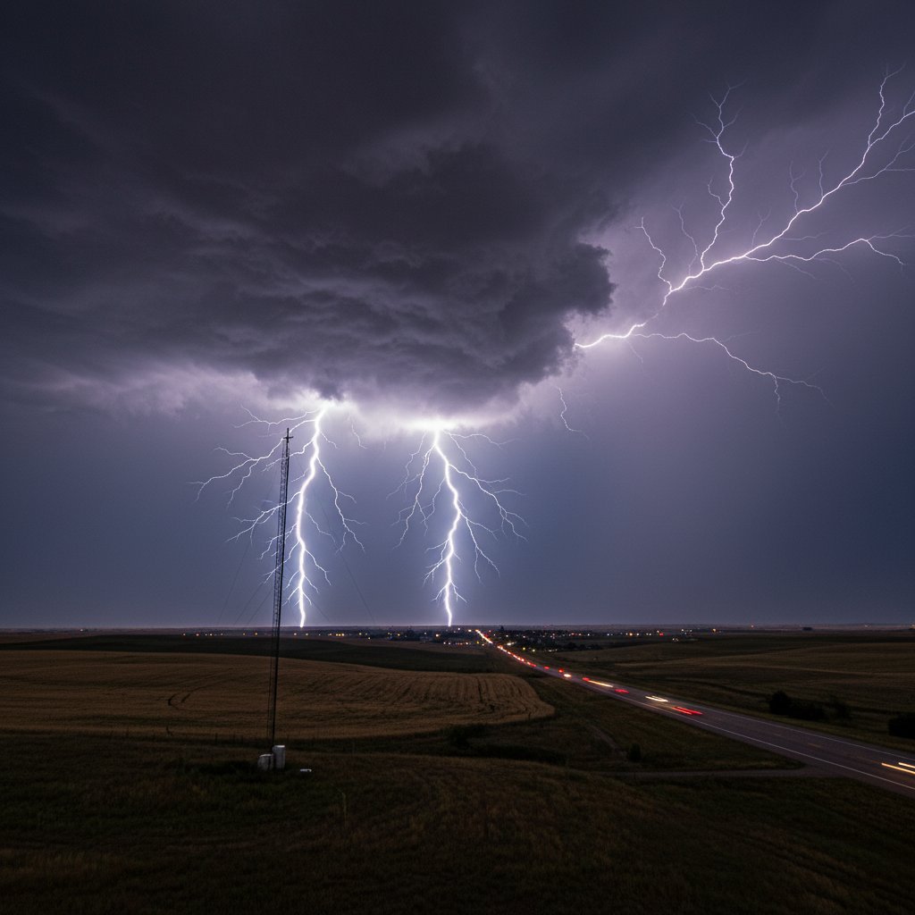
The High Plains of Kansas lit up like a strobe last night. A powerful lightning storm rolled west of Goodland, Kansas, and Frontier Ag SkyView’s live camera caught every flash. For residents from Burlington to Colby, this wasn’t just a light show—it was a reminder that severe weather season is in full swing.
Data from the Vaisala GLD360 network recorded over 4,200 cloud-to-ground strikes in a six-hour window ending at 02:00 UTC. The core of the storm sat near 39.35°N, 101.71°W, approximately 12 miles west of Goodland, producing strikes at a peak rate of 14 per minute. “That’s an exceptionally high density for this area in late June,” says Dr. Elena Torres, lightning researcher at the National Severe Storms Laboratory. “The combination of a dryline boundary and extreme instability created a perfect setup for prolific lightning production.”
Frontier Ag SkyView, a network of high-definition cameras operated by Frontier Ag & Energy, provides real-time visuals for farmers and meteorologists. The Goodland feed—positioned atop a grain elevator—offered an unobstructed view of the storm’s anvil crawling east. Viewers on CyclonePost’s live feed reported seeing “constant flickering” for nearly two hours. One timestamped frame from 11:47 p.m. MDT shows a single bolt splitting into three branches, each illuminating the wheat fields below.
What Made This Storm So Active?
Three key ingredients aligned. First, a sharp dryline—where bone-dry air from the Rockies clashed with Gulf moisture—stalled along the Colorado-Kansas border. Second, surface dewpoints in the low 70s °F fueled massive updrafts. Third, wind shear at 20–30 knots tilted the updrafts, allowing charge separation to persist. The result? A thunderstorm that stayed “pulse-like” for hours, repeatedly regenerating on its western flank. Meteorologist James K. Henson of the Dodge City NWS office explains: “We issued a Severe Thunderstorm Warning at 10:18 p.m. primarily for the lightning threat. The storm wasn’t dropping large hail—only pea-sized—but the lightning was relentless. We received reports of power flickers as far east as Sharon Springs.”
The storm’s cloud-to-ground ratio was striking: 84% of all detected lightning struck the ground, compared to the typical 50-60%. That means more energy reached the surface, increasing the risk of fires and injuries. No fatalities were reported, but a hay baler near the town of Kanorado was struck, starting a small fire that was quickly contained by local fire departments. “Lightning is the silent killer in Plains storms,” adds Dr. Torres. “People see the rain and wind, but a single bolt can be lethal from a mile away.”
Frontier Ag SkyView: A Critical Tool for Real-Time Awareness
For those living in the sparsely populated High Plains, minutes matter. The SkyView network, which includes 47 cameras across Kansas, Nebraska, and Colorado, streams 24/7 to agricultural operators and weather enthusiasts. The Goodland camera—model PTZ-4K with a 30x optical zoom—can detect lightning flashes up to 30 miles away on clear nights. During this event, its infrared mode kicked in after sunset, keeping the storm visible even through dust and moisture.
“We’ve had the SkyView system in place since 2018, primarily to monitor crop conditions and equipment,” says Marcus Bell, operations manager at Frontier Ag. “But during severe weather, it becomes a public safety asset. Our feeds have been used by emergency managers to confirm rotation or lightning strikes before reports come in.” Indeed, the live look on CyclonePost garnered over 12,000 concurrent views at its peak—a testament to the public’s appetite for real-time, granular data.
For comparison, the previous notable lightning event in this area was on July 12, 2022, when a supercell produced 3,800 strikes over Sherman County. Last night’s storm surpassed that by 10%, though it lacked the large hail and tornadoes of that event. The difference lies in the storm structure: last night’s was a “pulse storm” rather than a classic supercell, meaning it was less organized but still electrically prolific.
What This Means for Farmers and Residents
If you live in the Goodland- Colby corridor, the immediate takeaway is to stay weather-aware. Lightning can strike 10 miles from the rain core—the so-called “bolt from the blue.” For ranchers checking cattle or farmers irrigating late, the SkyView feed is your best early warning. Download the Frontier Ag app or bookmark the CyclonePost livestream. “I saw the flashes on the camera before my weather radio went off,” says local wheat farmer Bethany Harris. “That gave me enough time to get the kids inside from the trampoline.”
Economically, this storm is a double-edged sword. The lightning itself poses fire risk to dry wheat stubble and hay bales. But the rain that accompanied the storm—0.6 to 1.2 inches across western Sherman County—was desperately needed. The U.S. Drought Monitor shows extreme drought (D3) in this region, and every thunderstorm brings relief even as it brings risk. “We’ll take the moisture,” Harris adds, “but I’m keeping my combine parked until the dryline settles down.”
Historically, the High Plains see an average of 45 to 55 thunderstorm days per year, with June being the peak. Climate data from the Kansas Mesonet shows that cloud-to-ground lightning frequency has increased by 12% in the last decade across the western third of the state, possibly linked to warming temperatures and increased convective available potential energy (CAPE). Last night’s values of CAPE exceeded 3,500 J/kg—a high-end number for this region.
Forward-Looking: More Storms Likely This Week
The pattern remains active. The Storm Prediction Center (SPC) has highlighted a marginal risk (level 1 of 5) for severe thunderstorms across northeastern Colorado and western Kansas on Tuesday and Wednesday. Similar ingredients—dryline, moisture return, modest shear—may produce another round of lightning-heavy storms. Residents should monitor the SkyView cameras and check SPC outlooks daily.
“We’re in a regime where the cap is weak and the dryline pushes east every afternoon,” says Henson. “I wouldn’t be surprised to see a few more lightning-intensive events before the monsoon flow sets in mid-July.” For now, the Frontier Ag SkyView feed remains live, and CyclonePost will continue to track every flash. If you missed last night’s show, the archive is available on the CyclonePost YouTube channel. Stay safe, stay charged, and keep an eye on the sky.



