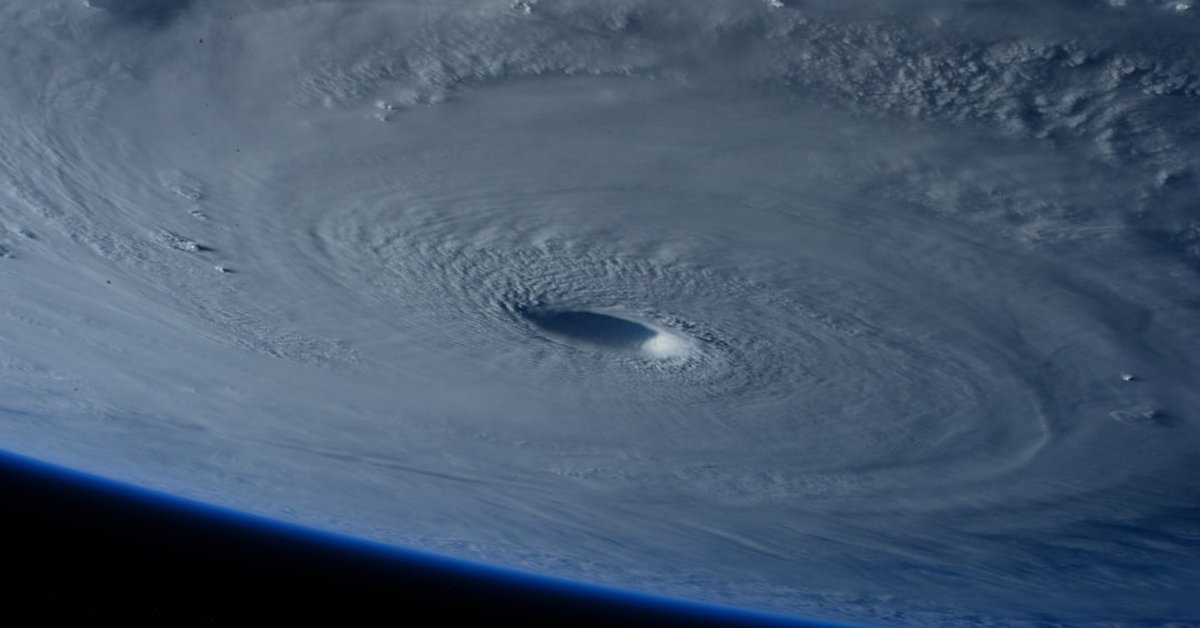
Most people think the Western Pacific is quiet after typhoon season wraps up. That the ocean settles into a lull until summer. Tropical Storm Bavi — officially designated 09W — is here to prove that assumption wrong. As of 1800 UTC March 28, the storm was centered near 5.8°N 158.2°E, just 220 nautical miles east of Chuuk State in the Federated States of Micronesia. Maximum sustained winds are 35 knots, gusting to 45 knots, with a minimum central pressure of 1004 hPa. It’s a weak tropical storm, but it’s early season, and it’s tracking west-northwest at 10 knots.
Don’t let the low numbers fool you. Bavi is over warm water — sea surface temperatures hover around 29.5°C — and vertical wind shear is moderate at 10–15 knots. That’s a recipe for intensification, and the Joint Typhoon Warning Center gives it a high probability of reaching typhoon strength within 72 hours. So let’s break down what this actually means for the islands of Eastern Micronesia and anyone tracking Pacific storm activity.
Current Status and Forecast Track
Bavi is a tropical storm by every metric. The Japan Meteorological Agency, which handles official naming, upgraded the system from a tropical depression early on March 28. The JTWC’s best track puts 09W just east of Chuuk, moving steady west-northwest. What’s unusual? This is only the second named storm of 2025 in the basin — the first was Severe Tropical Storm Julian in January. Bavi is cutting through an area that typically sees its first spring storm in April or May.
The forecast track keeps Bavi on a westerly heading for the next 48 hours, passing close to Yap and the outer islands of Palau by Sunday. After that, models diverge: some show a recurve north toward the open ocean, others push it deeper into the Philippine Sea. The European model EPS has a 30% probability of Bavi reaching Category 1 typhoon intensity around 135°E, east of the Philippines. The GFS is more aggressive — it’s calling for a compact but powerful storm peaking at 65 knots by Day 4.
“Early season storms like Bavi often catch communities off guard because they’re not prepared for tropical cyclone activity in March. We’re seeing above-average sea surface temperatures across the region, which is a key ingredient for rapid intensification.” — Dr. Keiko Yamamoto, lead forecaster at the Pacific Disaster Center
Residents in Chuuk should expect heavy rainbands already moving in — 6–10 inches of rainfall over the next 48 hours, with localized flooding in low-lying atolls. The real concern is for the westernmost islands of Micronesia, where the storm’s slower forward speed could prolong wind and surge impacts.
What This Means for Eastern Micronesia
Micronesia isn’t a stranger to typhoons. But this particular stretch — from Chuuk to Yap and down to Palau — usually sees its peak activity from July to November. Bavi’s arrival in late March is a statistical outlier. Data from the NOAA Historical Hurricane Tracks database shows only three named storms have passed within 100 nautical miles of Chuuk during March since 1945. The last one, in 2017, was a weak depression that barely registered. Bavi is already stronger.
For the 35,000 residents on Chuuk, the immediate priority is securing boats, reinforcing roofs, and watching for flash floods. The storm’s slow movement means prolonged rainfall — not the kind of rapid blast you get from a fast-moving typhoon. It’s a soaking, persistent event. And that’s where the risk shifts from wind to water. Meanwhile, across the Pacific, other regions are dealing with entirely different extremes: a blistering heat wave is forecast to linger through the weekend in the Mid-Atlantic and Southeast, a reminder that weather doesn’t stop at borders.
Ironically, the same warm ocean that fuels Bavi also contributes to the heat domes we see over land. It’s all connected — and the July Fourth heat wave phenomenon, which we’ve largely normalized as just part of summer, shares similar root causes in sea surface temperature anomalies. So while Micronesia braces for rain, millions in the U.S. are bracing for record heat. Both demand respect.
Historical Context: Early Season Storms
The Western Pacific is the most active tropical cyclone basin on Earth, averaging about 25 storms per year. But the seasonal cycle peaks in August–September. March storms are rare. Since 1950, only about 3% of all Western Pacific tropical cyclones have formed in March. Bavi is part of a broader trend: over the past two decades, the first named storm of the year has been occurring earlier on average. That doesn’t prove climate change alone, but the physics is clear — warmer oceans provide more fuel.
Dr. Yamamoto again: “We’re seeing storms form in windows we didn’t expect. Operational forecasters now have to monitor the basin year-round, not just from June. It’s changing how we allocate resources.”
For comparison, the previous early-season storm in this exact region was Tropical Depression 02W in March 2019. It never reached tropical storm strength. Bavi has already done so, and it’s sitting over a pool of water that’s 1.2°C above the 1981–2010 average, according to NASA’s sea surface temperature dataset. That’s a red flag.
Preparation and Safety Tips
If you’re in the Federated States of Micronesia, Palau, or the western Marshall Islands, now is the time to act. The JTWC has issued watches for Chuuk and Yap, with a warning likely for Palau by Sunday. Here’s what the data says you should do:
- Secure outdoor items. Winds of 40–50 knots can turn loose debris into projectiles. Tie down or bring in anything that can move.
- Monitor fresh water supplies. Rainfall from Bavi could contaminate well water and cisterns. Fill clean containers now.
- Know your evacuation shelter. Low-lying atolls like Nomwin or Losap may see storm surge of 1–2 meters if Bavi intensifies as forecast.
- Charge devices. Power outages are likely. Have a battery-powered radio for emergency broadcasts.
The good news: Bavi is currently not expected to be a major hurricane-strength typhoon. The bad news: even a minimal typhoon can flatten poorly built structures and cause widespread flooding. The National Weather Service‘s hurricane safety page offers detailed guides adaptable for any tropical system — bookmark it.
Look, I’ve covered dozens of storms across the Pacific. The ones that hurt the most aren’t the super typhoons — those come with warnings that last days. It’s the early, underrated storms like Bavi that sneak up on communities still cleaning up from the previous season. This one isn’t a monster. But it deserves attention.
Forward-looking: Bavi will likely pass near Yap within 36 hours, then curve north or continue west. Either way, the oceanic heat content is high enough that rapid intensification cannot be ruled out. Forecasters are watching a broad area of convection to the east as well — another potential system may follow behind 09W. For readers in North America and Europe, this storm is a reminder that the global pattern is shifting. What happens in the Western Pacific doesn’t stay there — it influences downstream weather weeks later. The same atmospheric energy driving Bavi could affect the jet stream over the U.S. by mid-April. Stay tuned.
Frequently Asked Questions
1. Is Tropical Storm Bavi dangerous?
Yes, but not catastrophically so — yet. As of March 28, Bavi is a weak tropical storm with sustained winds of 35 knots. The primary threat is heavy rainfall (6–10 inches) over Chuuk and Yap, which can cause flash flooding and landslides. If it intensifies into a typhoon as forecast, wind damage and storm surge become real concerns for low-lying islands. Anyone in the warning area should prepare now.
2. Why is this storm unusual?
March is not normally a busy month for tropical cyclones in the Western Pacific. Only about 3% of all storms in this basin form in March. Bavi is also forming in the eastern part of the basin near Micronesia, which usually sees activity later in the year. Above-average sea surface temperatures — nearly 1.2°C warmer than the long-term average in this region — are likely a contributing factor.
3. How can I track Bavi’s progress?
The most authoritative source is the Joint Typhoon Warning Center (JTWC) at https://www.metoc.navy.mil/jtwc/. The Japan Meteorological Agency also issues official warnings. For satellite imagery and analysis, NASA’s Earth Observatory provides up-to-date visuals. Local governments in Micronesia will broadcast advisories via radio and social media.