







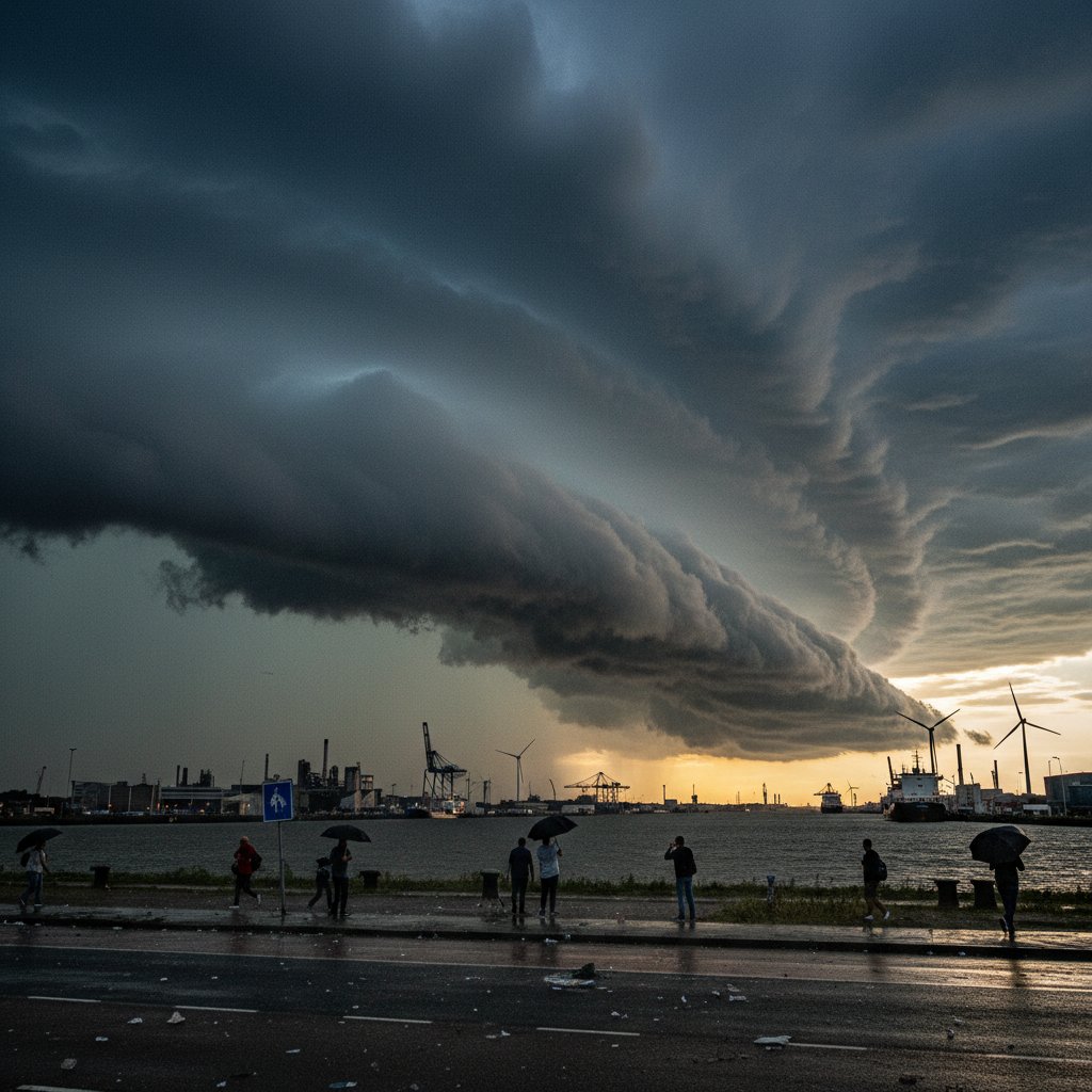
You see the photos and you think: that’s not real. That’s a movie set for some apocalyptic blockbuster, or maybe a digital artist showing off. But last weekend, residents of Terneuzen, a port city in the southwestern Netherlands, looked up and saw something that defied easy explanation. A massive, rolling shelf cloud stretched across the Scheldt estuary, low and menacing, like the sky had decided to go horizontal. It wasn’t a tornado. It wasn’t a hurricane. But for the 55,000 people who live there, it was a moment of collective awe — and a stark reminder that our atmosphere is doing things we don’t fully understand.
Let’s be clear: shelf clouds aren’t rare. But the one that formed over Terneuzen on Saturday afternoon was something else. It extended for miles, a dark, wedge-shaped arc that seemed to swallow the horizon. People pulled over on the N61 highway. Kids stopped playing in their yards. Everyone had a phone out. And by Sunday morning, the footage had gone global — shared by weather enthusiasts, climate scientists, and frankly, anyone who appreciates a good sky drama.
What Actually Happened Over Terneuzen?
Shelf clouds form along the leading edge of a thunderstorm’s outflow — that rush of cool air that spills out ahead of the storm itself. Think of it like a snowplow: the storm pushes cold air forward, and that air lifts the warm, moist air in front of it. When that warm air rises and condenses, you get a shelf cloud. Simple in theory. But in practice? The Terneuzen shelf cloud was anything but textbook.
Meteorologists at the Royal Netherlands Meteorological Institute (KNMI) confirmed that the storm system responsible was part of a larger weather pattern moving across the North Sea. Temperatures had climbed into the low 30s Celsius (mid-80s Fahrenheit) earlier that week — part of the same heat wave that’s been sweating through Europe for the better part of a month. That heat, combined with moisture from the North Sea, created the instability needed for such a dramatic formation.
“What we saw in Terneuzen was a particularly well-defined shelf cloud,” says Dr. Lotte van der Meer, a meteorologist at Utrecht University. “The contrast between the cool outflow and the warm, humid air ahead was extreme. That’s what gave it that sharp, almost surgical edge.”
And that edge is what made the photos so arresting. The cloud base was almost perfectly flat, like someone had taken a cosmic knife and sliced the sky in half. Below it, the air was hazy and gray. Above, a brilliant blue. It was a visual line between two worlds.
More Than Just a Pretty Sky
But here’s the thing: shelf clouds aren’t just cool to look at. They’re also harbingers. They signal the arrival of severe weather — heavy rain, strong winds, sometimes hail. In the case of Terneuzen, the storm that followed brought gusts up to 90 kilometers per hour (56 mph), downed trees, and localized flooding. A few cars were damaged by falling branches. No injuries were reported, but it was a close call for some.
“People see the cloud and they think it’s the main event,” says Mark Hendricks, a storm chaser and weather photographer based in Amsterdam. “But the shelf cloud is just the opening act. The real show — the wind, the rain, the potential danger — comes right after. I’ve seen folks stand there filming while the storm is literally on top of them. It’s beautiful, but it’s also a storm.”
This is where the story gets bigger than Terneuzen. The Netherlands has seen a spike in severe weather events over the past decade. According to data from the European Severe Weather Database, the country experienced 47 confirmed thunderstorm wind events in 2023 — up from 28 in 2013. That’s a 68% increase. And while you can’t pin any single shelf cloud on climate change, the conditions that create them — heat, humidity, instability — are exactly what a warming world is serving up.
Look, we’ve been talking a lot about heat this summer. The quiet killer that’s claimed more lives in the U.S. than any other weather threat. But the flip side of extreme heat is extreme storms. Hot air holds more moisture. More moisture means more fuel for thunderstorms. And more thunderstorms mean more shelf clouds — and the violence they bring.
What It Means for You
If you live in the U.S., the U.K., or Canada, you might be thinking: “Okay, but this happened in the Netherlands. Why should I care?” Fair question. Here’s the answer: weather doesn’t respect borders. The same atmospheric dynamics that produced the Terneuzen shelf cloud are playing out across the Northern Hemisphere this summer. In the U.S., the Midwest has seen a rash of derecho events — essentially, long-lived thunderstorm complexes that produce widespread wind damage. In the U.K., the Met Office has issued more severe thunderstorm warnings this July than in any July on record.
And here’s something that doesn’t get talked about enough: the economic cost. Storms like the one in Terneuzen cause disruptions — closed roads, delayed shipping, damaged infrastructure. The Port of Terneuzen, one of the largest in the region, had to pause operations for several hours. That’s not just an inconvenience; it’s a hit to the supply chain. Storms also cause car accidents, as drivers lose control on wet roads or get blindsided by sudden gusts. The legal fallout from those crashes can drag on for months.
“We’re seeing a pattern where these events are becoming more frequent and more intense,” says Dr. van der Meer. “It’s not about panic. It’s about preparedness. Cities like Terneuzen need to think about how they handle these storms — better drainage, stronger infrastructure, public awareness campaigns. Because this isn’t a one-off.”
She’s right. The shelf cloud over Terneuzen was a warning — a beautiful, terrifying, unforgettable warning. And we’d be fools to ignore it.
So next time you see a photo of a shelf cloud rolling in, don’t just marvel at the aesthetics. Ask yourself: what’s coming next? Because in a world where the weather is rewriting the rules, the answer is never just a pretty picture.
Frequently Asked Questions
What exactly is a shelf cloud?
A shelf cloud is a low, horizontal cloud formation that appears along the leading edge of a thunderstorm’s outflow. It forms when cool air from the storm pushes forward and lifts warm, moist air ahead of it, causing condensation. It often looks like a dark, wedge-shaped arc and is a sign that severe weather — like strong winds, heavy rain, or hail — is approaching.
Was the Terneuzen shelf cloud dangerous?
The cloud itself wasn’t dangerous, but the storm it preceded was. Winds reached up to 90 km/h (56 mph), causing downed trees and localized flooding. No injuries were reported, but several cars were damaged by falling branches. Meteorologists warn that shelf clouds should be treated as a signal to seek shelter, not as a photo opportunity.
Is climate change making shelf clouds more common?
While no single shelf cloud can be directly attributed to climate change, the conditions that form them — extreme heat, high humidity, and atmospheric instability — are becoming more frequent in a warming world. Data from Europe shows a significant increase in thunderstorm wind events over the past decade, suggesting that severe weather, including shelf cloud-producing storms, is on the rise.



