







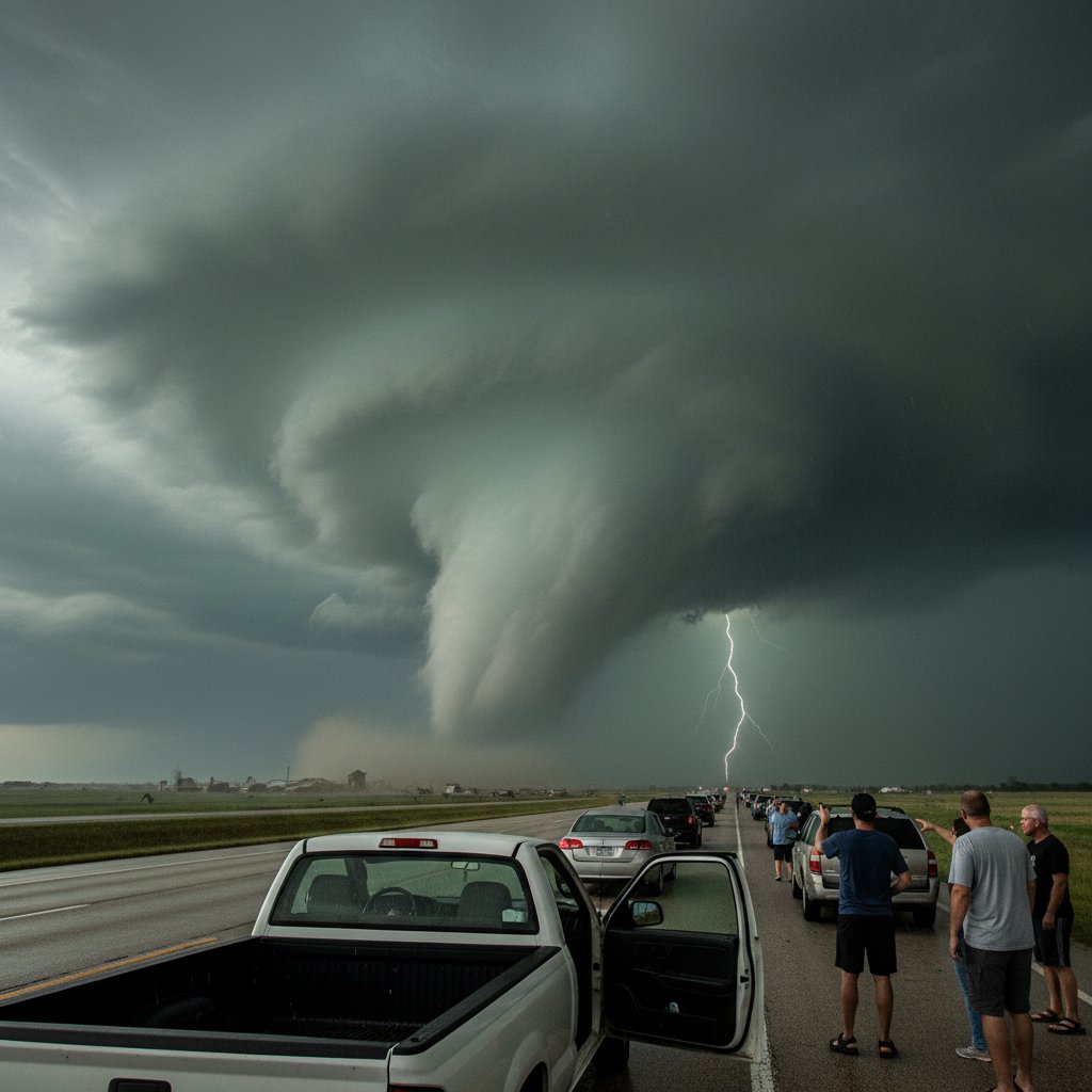
On June 9, 2026, a driver heading west on Interstate 70 near Maple, Kansas, pointed a phone at the sky and captured something that would soon divide storm chasers, meteorologists, and social media users alike. The footage, grainy and shot through a rain-streaked windshield, shows a dark, rotating column dipping from a low-hanging cloud base. It lingers for perhaps 30 seconds before being swallowed by a wall of rain. The question being asked across weather forums? Was it a tornado?
The answer is more complicated than you might think. And it carries real consequences for how we understand severe storms in the Plains.
A Visual Puzzle on I-70
The video, first shared on X (formerly Twitter) by a trucker using the handle @FlatlandHauler, has racked up more than 2 million views in less than 48 hours. In it, the funnel appears to touch the ground—but only briefly. Some viewers insist they see debris spinning at the base; others argue it’s just a scud cloud or a rain shaft.
“The public is actually getting pretty good at spotting tornadoes,” says Dr. Anne Lindstrom, a research meteorologist with the National Severe Storms Laboratory in Norman, Oklahoma. “But this one is tricky because it’s a classic ‘rope out’—a thin, dissipating funnel that may or may not have been in contact with the ground.”
The location adds to the confusion. Maple, Kansas, sits in a region where the topography can obscure low-level rotation. Hills and tree lines along I-70 can make it hard to confirm a touchdown from ground level alone.
Why It Matters: The 2026 Kansas Tornado Season
According to the National Weather Service in Wichita, June 9 was part of an active multiday severe weather outbreak across central Kansas. On that same day, three confirmed tornadoes touched down in Cowley County to the south, and a damaging EF-2 struck near Medicine Lodge. The system that spawned those storms was still vigorous as it pushed into Morris County, where Maple is located.
“If this was a tornado, it would be a significant data point,” explains Marcus Garza, a senior forecaster at the Storm Prediction Center in Norman, Oklahoma. “It would mean the supercell maintained its rotation longer than radar indicated. That has implications for future warnings.”
Radar data from the time shows a moderate mesocyclone about 4,000 feet above the ground, but no clear convergence at the surface. Doppler radar velocities were ambiguous—enough to issue a Severe Thunderstorm Warning but not a Tornado Warning. Yet eyewitness reports like the one on I-70 suggest something was happening at ground level.
“The gap between what radar sees and what people see is shrinking, but it’s still there,” says Dr. Emily Hartwell, a storm dynamics researcher at the University of Kansas. “Every one of these ambiguous events helps us refine our algorithms.”
Human Impact: The People Caught in the Storm
The driver, who has chosen to remain anonymous, later told local news that he pulled over and took cover behind a concrete barrier until the worst passed. “I’ve been driving these roads for 20 years,” he said in an interview with Kansas City Star. “That didn’t look like any cloud I’ve seen before. But I wasn’t about to wait around to find out.”
His caution was warranted. Just 30 minutes later, the same storm produced a confirmed EF-1 tornado near Council Grove, about 12 miles east, which damaged two farmsteads and injured one person. The National Weather Service is now re-evaluating the storm’s path to see if the Maple funnel was a precursor or part of the same circulation.
For the residents of Maple—a tiny unincorporated community of fewer than 100 people—the uncertainty is frustrating. “We don’t have a siren here,” says Bethany Orton, a lifelong resident who witnessed the storm from her front porch. “If it was a tornado, we’d want to know so we can be ready next time. But nobody from the Weather Service has come out yet.”
That delay is not unusual. Ground surveys take time, and the NWS prioritizes areas with confirmed damage. In this case, no damage has been reported near Maple, making the event a “possible tornado”—a classification that sits between confirmed and rejected.
The Bigger Picture: Tornadoes in a Changing Climate
This incident also fits into a larger conversation about severe weather trends. Research published in 2024 by the National Center for Atmospheric Research indicates that while the total number of tornadoes annually has not increased dramatically, the proportion of high-end events (EF-3 and above) has risen in the central Plains. Meanwhile, the season is shifting: more tornadoes are occurring in late spring and early summer, and they are clustering in time—sometimes dozens in a single outbreak.
“Storms like the one on June 9 are becoming harder to categorize in real time because they are embedded in messy environments with high moisture and strong wind shear,” notes Dr. Lindstrom. “The line between a funnel cloud and a tornado can be razor-thin.”
That line is also expensive. Tornado warnings trigger school closures, factory shutdowns, and highway traffic jams. False alarms erode public trust. But missed warnings cost lives. The I-70 video is a reminder that weather science still relies on human eyes and phone cameras to fill the gaps.
What Happens Next
As of today, the National Weather Service in Wichita says survey teams are reviewing satellite imagery and additional dashcam footage to make a final determination. They expect a ruling within a week. If the funnel is classified as a tornado, it will be listed as an EF-U (unknown) in the official records, with a note about the uncertain duration.
For storm chasers and weather enthusiasts, the debate will continue. For the people of Maple, the lesson is already clear: when you see a rotating cloud on the Kansas horizon, don’t wait for a warning. The sky can change—and the answer to “is this a tornado?” can arrive too late.
As Dr. Hartwell puts it, “The public is our most valuable sensor network. That footage from I-70 might not be a textbook tornado, but it’s a textbook example of why we need to keep watching.”



