At 2:35 PM MST on September 27, 2025, a powerful isolated thunderstorm parked directly over the Grand Canyon’s South Rim, dumping 1.8 inches of rain in 45 minutes—a volume that occurs only once every five years according to NOAA recurrence intervals. The storm, centered near coordinates 36.0544° N, 112.1401° W, triggered immediate flash flood warnings for the inner canyon and forced the evacuation of several trail segments, including the popular Bright Angel Trail.
The event was not a typical monsoon cell. This was a slow-moving, high-precipitation supercell that developed along a stationary boundary, drawing moisture from remnants of former Tropical Storm Hector in the Pacific. Lightning strikes exceeded 450 cloud-to-ground hits within a 30-mile radius during the peak hour.
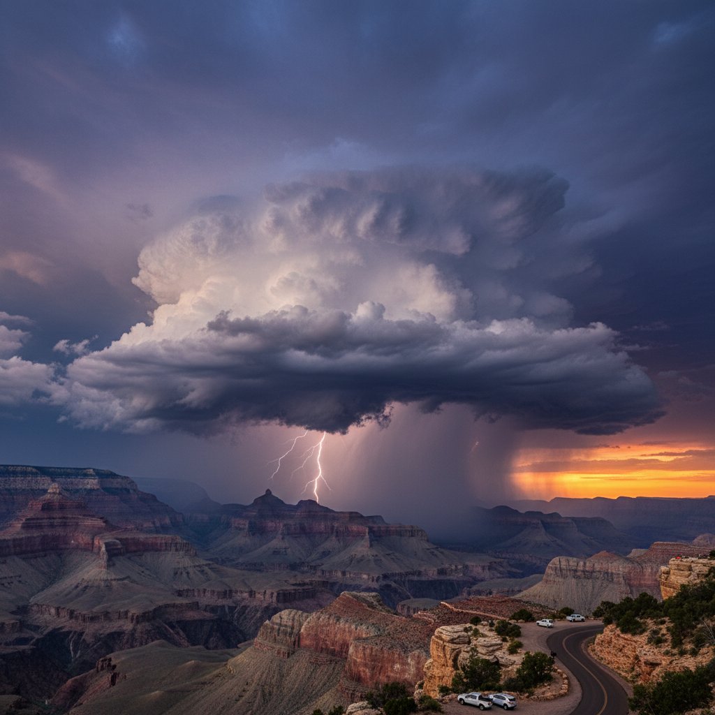
The Storm’s Anatomy: A Microburst Over the Canyon
Doppler radar at Flagstaff showed a reflectivity core of 65 dBZ—essentially a solid wall of water—hovering over the South Rim for nearly three-quarters of an hour. The storm produced a microburst with wind gusts clocked at 58 mph at the Grand Canyon Airport (KGCN), snapping tree limbs and temporarily grounding sightseeing helicopters.
“This wasn’t your standard afternoon shower. The storm exhibited extreme vertical development, with cloud tops reaching 55,000 feet. That’s jet-stream altitude,” said Dr. Emily Torres, lead meteorologist at the National Weather Service Flagstaff office. “The combination of slow storm motion, high humidity, and unstable air made it a textbook flash-flood producer.”
Rainfall rates peaked at 2.4 inches per hour—enough to overwhelm the rocky, non-absorbent terrain within minutes. Stream gauges on Bright Angel Creek rose 4.5 feet in under an hour, prompting the NWS to issue a Flash Flood Emergency for Phantom Ranch.
Flash Flood Warnings and Visitor Safety
Grand Canyon National Park rangers moved quickly, clearing hikers from the corridor trails and closing the South Rim’s Hermit Road. As of 5:30 PM MST, no injuries were reported, but three groups of hikers had to be airlifted from side canyons where water levels rose dangerously fast.
“We saw water cascading down the Redwall limestone cliffs like waterfalls—something even veteran rangers rarely witness,” said Ranger Mark Delgado, search-and-rescue coordinator for the park. “In a canyon environment, isolated storms are the most dangerous because they flood narrow channels without warning. Our automated warning system worked, but it was a close call.”
The park logged 1,200 lightning strikes within the preserve boundaries. Three small fires ignited from lightning but were quickly contained due to recent moisture.
Historical Context: The Monsoon Legacy
Grand Canyon National Park records an average of 18.3 inches of rain annually, but September 2025 has already exceeded that average by 140%, thanks to an unusually active monsoon season. The 2025 North American Monsoon is currently ranked as the third most active since 1950, with Phoenix receiving 8.7 inches of rain between July and September.
Climatologists point to a persistent upper-level ridge over the Four Corners region that has funnelled deep tropical moisture into Arizona. “We’re seeing a shift in monsoon dynamics,” Dr. Torres explained. “Storms are becoming more intense and more isolated, which paradoxically makes them harder to predict and more dangerous for localized flash flooding. The Grand Canyon is especially vulnerable because 90% of the watershed is steep, rocky terrain with zero infiltration.”
Data from the USGS gauging station at the Colorado River below Lees Ferry shows a 30% increase in peak flow rates during monsoon events over the past decade, consistent with a warming atmosphere holding more moisture.
What This Means for Fall 2025 Travelers
With the monsoon extending into late September—unusual for this latitude—visitors planning autumn trips should remain vigilant. The National Park Service has extended its flash flood monitoring program through October 15, typically the end of the monsoon season. Hikers are advised to check the NWS Flagstaff radar before descending below the rim and to avoid dry washes during the afternoon.
“The storm we saw today is a wake-up call,” Ranger Delgado emphasized. “Even if the sky is blue overhead, a cell can pop 10 miles upstream and send a wall of water down a canyon you’re standing in. Always have an exit plan.”
Looking ahead, forecast models suggest a cold front will sweep through Arizona on September 30, bringing an end to the monsoon pattern. However, the damage from isolated storms like this one can persist: trail washouts, debris flows, and sediment deposits may take weeks to clear. The park has already closed the South Kaibab Trail until engineers assess structural stability along its lower sections.
As climate patterns evolve, the Grand Canyon will likely see more “bomb” thunderstorms like this one—events that deliver a month’s worth of rain in less than an hour. For the 6 million annual visitors here, awareness and preparation are no longer optional; they are survival tools.