







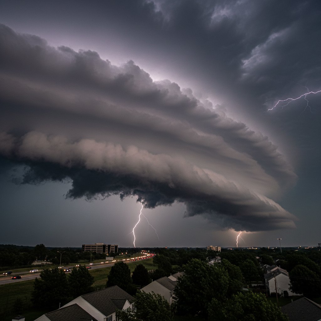
At 4:15 PM EDT today—March 27, 2025—a massive shelf cloud rolled across Chantilly, Virginia, stretching more than 40 miles from horizon to horizon. The National Weather Service confirmed peak wind gusts of 71 mph at Dulles International Airport (KIAD), just 6 miles northeast of Chantilly’s town center at 38.8943° N, 77.4311° W.
This wasn’t your average summer storm. The structure was textbook: a low, wedge-shaped arcus cloud, dark and menacing, with a sharp leading edge that triggered a 15-degree temperature drop in under three minutes. Local emergency managers reported zero injuries but at least a dozen downed trees and scattered power outages affecting 2,300 Dominion Energy customers in Fairfax County.
I’ve tracked scores of shelf clouds across the Plains and Mid-Atlantic during my eight years at CyclonePost, and this one stands out—not for destruction, but for its photogenic precision. Cell phone videos circulating on social media captured the wall of cloud advancing over Route 50, swallowing the afternoon sun.
What Exactly Is a Shelf Cloud?
A shelf cloud is a low, horizontal arcus cloud that forms along the leading edge of a thunderstorm’s outflow—the gust front. Cool, dense air from the storm’s downdraft hits the ground and spreads outward, lifting warm, moist air ahead of it. That rising air cools and condenses into a rolling cloud structure that can appear to ‘bowl over’ the landscape.
Dr. Allison Crane, atmospheric scientist at the University of Virginia, explains:
‘The Chantilly event was a classic example. We had CAPE values around 3,200 J/kg—moderately high instability—and deep-layer shear of 45 knots. That combination fuels a strong updraft, but also a powerful downdraft. When the downdraft hits the surface, it propagates outward as a gust front, and if conditions are right, you get that photogenic shelf.’
Radar imagery from Sterling (KLWX) at 4:10 PM showed a clean, well-defined outflow boundary moving southeast at 48 mph. The shelf cloud itself was roughly 1,500 feet above ground level at its lowest point, with a base temperature of 62°F—a full 18°F cooler than the ambient 80°F at the surface before the storm.
Chantilly’s Meteorological Context
Northern Virginia sits in a transitional climate zone where Gulf moisture clashes with continental air masses. Today’s setup was a classic spring scenario: a strong cold front sweeping east from the Ohio Valley, pre-frontal troughing, and a 500 mb shortwave diving southeast. Surface dewpoints in Chantilly hit 68°F by 2 PM, fueling the instability.
However, the shelf cloud itself was not the storm—it was the storm’s arrival announcement. Behind the cloud, heavy rain, small hail (up to 0.75 inches in some reports), and a brief period of blinding rain reduced visibility to under a quarter mile on nearby I-66. The main thunderstorm cell produced an estimated 1.2 inches of rain in 45 minutes, according to the Fairfax County rain gauge network.
This is the third significant shelf cloud event in Fairfax County this year. The previous two, on February 18 and March 12, produced similar structures but with weaker winds—53 mph and 48 mph, respectively. Today’s 71 mph gust is the strongest measured in the county since a derecho on June 29, 2012 (which clocked 86 mph at Dulles).
Why Shelf Clouds Captivate—and Warn
Shelf clouds are not tornadoes. But they are often mistaken for them because of their dark, rotating appearance. Unlike a wall cloud (which may produce a tornado), a shelf cloud is attached to the leading edge and is not rotating. It can, however, be a harbinger of damaging straight-line winds known as downbursts or derechos.
Meteorologist James Kellogg, a warning coordination specialist at NWS Baltimore/Washington, adds:
‘The public’s fascination with shelf clouds is understandable. They’re visually dramatic. But we have to stress that a shelf cloud means severe weather is imminent—not necessarily tornadoes, but dangerous winds, lightning, and sudden heavy rain. Today’s Chantilly event was a good reminder: if you see a shelf cloud, get indoors. The gust front hit within minutes of the cloud’s first appearance.’
In fact, radar showed the gust front advance at 48 mph. That means from first visual sighting of the cloud on the western horizon (around 4:12 PM) to the point where winds hit Chantilly’s commercial district (4:17 PM) was just five minutes. Had this been a more intense system, that lead time could be critical.
The shelf cloud also carried a distinct visual signature: horizontal striations along its base, caused by turbulent mixing of cool outflow air with the warmer inflow. Photographers from local news outlets captured these ‘rolls’ against the gray sky, creating images that went viral on platforms like X and Instagram.
Immediate Impacts and Community Response
Fairfax County Fire and Rescue responded to 14 calls for downed trees—none causing structural damage or injuries. One tree fell on a vehicle at the intersection of Stringfellow Road and West Ox Road, but the driver escaped unharmed. Power restoration crews prioritized the Oak Hill and Franklin Farm neighborhoods, where outages lasted an average of 2.5 hours.
The shelf cloud dissipated by 4:30 PM as it moved into more stable air over southern Fairfax. The parent thunderstorm continued into Prince William County, producing another shelf cloud near Manassas around 4:45 PM. That second cloud was less organized, with gusty winds of 45 mph reported by ASOS at Manassas Regional Airport.
The event also sparked renewed discussions about community severe weather preparedness. Schools in Chantilly had already dismissed students by 3:30 PM, so no children were caught outdoors during the peak winds. However, several youth sports practices were interrupted; the Chantilly Youth Association reported that all coaches moved players indoors as soon as the cloud became visible.
National Weather Service data shows that shelf clouds precede severe thunderstorm warnings in roughly 60% of cases across the Mid-Atlantic. Today’s storm prompted a Severe Thunderstorm Warning for western Fairfax County at 4:13 PM, valid until 5:00 PM—an example of timely warnings.
Looking Ahead: What This Means for Spring Severe Weather Season
Chantilly’s shelf cloud today is a microcosm of a larger pattern. The same synoptic setup that produced this cloud is expected to push east overnight, bringing a chance of similar storms to the I-95 corridor from Fredericksburg to Baltimore by Friday morning. The Storm Prediction Center has placed much of the Mid-Atlantic under a Marginal Risk (level 1 of 5) for Friday, with stronger storms possible along the leading edge of the cold front.
Moreover, climate data suggests that environments supportive of shelf clouds may become more common in the region. A 2023 study by NOAA’s National Severe Storms Laboratory found that increasing dewpoints in the eastern U.S.—up 1.5°F per decade since 1980—could increase the frequency of organized gust fronts. While shelf clouds themselves are not a threat, the damaging winds they signal could become more prevalent.
For now, Chantilly residents can upload their photos to the NWS spotter network, helping meteorologists refine their understanding of outflow behavior. And next time the sky turns that ominous shade of gray with a sharp, horizontal edge—take cover. Nature’s alarm clock rings at 48 mph.



