Every thunderstorm begins as a cloud. But not just any cloud. When you look up and see a flat, dark base stretching across the horizon like an anvil, or a rotating, lowering funnel, you’re looking at something that could turn dangerous. The question “What kind of clouds are these?” is more than a curiosity—it’s a survival skill.
Understanding cloud types can give you precious minutes of warning before lightning strikes, hail falls, or a tornado touches down. Here’s what to look for and what it means.
The Classic Thunderhead: Cumulonimbus
The most notorious cloud in severe weather is the cumulonimbus. These towering giants can reach 60,000 feet into the atmosphere. Their tops flatten into an anvil shape when they hit the tropopause—the boundary between the troposphere and stratosphere. If you see an anvil cloud on a summer afternoon, you are looking at a fully developed thunderstorm.
“Cumulonimbus clouds are the engine of severe weather,” says Dr. Karen St. James, meteorologist at the National Severe Storms Laboratory. “They produce everything from torrential rain and hail to microbursts and tornadoes. The key is the vertical development—the taller the cloud, the more energy it stores.”
These clouds form when warm, moist air rises rapidly. If the atmosphere is unstable, the updraft can intensify, turning a benign puffy cloud into a monster. In the United States, such storms are most common in the Great Plains and the Southeast, but they can form anywhere from London to Vancouver.
Low-Hanging Danger: Shelf Clouds, Wall Clouds, and Scud
Not all threatening clouds are towering. Some are low, dark, and moving fast. A shelf cloud often precedes a strong thunderstorm. It looks like a dark, wedge-shaped roll attached to the front of a storm. “A shelf cloud is a sign of the storm’s outflow—cold air rushing out and lifting warm air ahead of it,” explains retired airline pilot and storm chaser James Corrigan. “When you see a shelf cloud moving toward you, you’re about to get hit by strong winds and heavy rain. It’s not a tornado, but it can produce damaging straight-line winds.”
More dangerous is the wall cloud. This is a localized, persistent lowering from the rain-free base of a thunderstorm. Wall clouds can rotate, and when they do, they often spawn tornadoes. “A wall cloud is like a red flag,” says Corrigan. “If you see one, take shelter immediately. Not every wall cloud produces a tornado, but every tornado comes from a wall cloud.”
Beware of scud clouds, which are ragged, low-hanging fragments that are not attached to the storm’s updraft. They often form in the rain-cooled air under a storm and can be mistaken for wall clouds. The difference: scud clouds move quickly and dissipate, while wall clouds persist and often rotate.
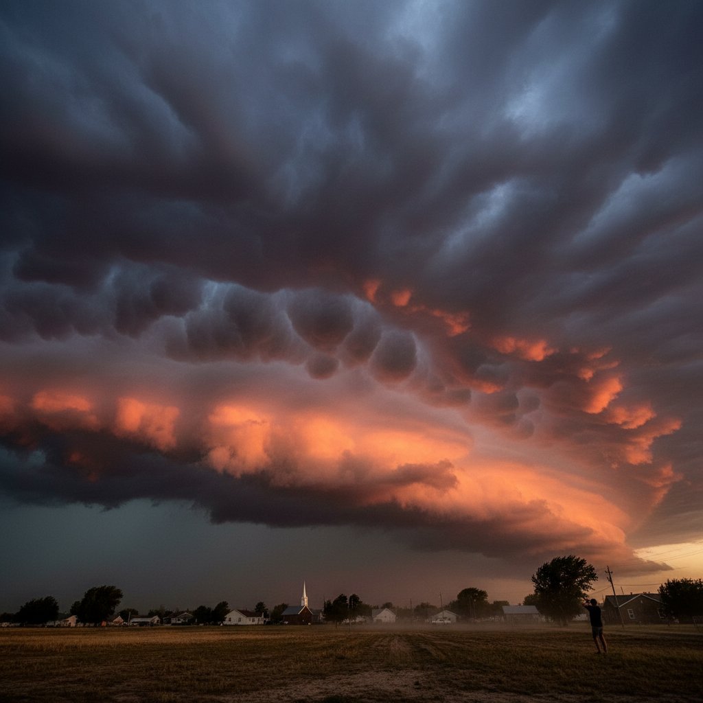
Strange and Beautiful: Mammatus, Lenticular, and Roll Clouds
Some clouds look alien but are harmless—or at least not directly dangerous. Mammatus clouds appear as pouch-like bulges hanging under the anvil of a cumulonimbus. They are actually pockets of sinking, cold air. Despite their ominous appearance, mammatus clouds do not produce severe weather themselves, but they are often associated with the most violent thunderstorms. “Mammatus are the thunderstorm’s signature after the punch,” says Dr. St. James. “If you see them, the storm has passed its peak, but it was a powerful one.”
Lenticular clouds look like smooth, flying saucer shapes that form near mountains. They are created by stable moist air flowing over a mountain peak. While stunning, they are not storm clouds—they often signal turbulence aloft, but not severe weather on the ground. Roll clouds, on the other hand, are horizontal, cylindrical tubes that appear to rotate about a horizontal axis. They are a type of arcus cloud and usually precede a gust front. Unlike a shelf cloud, a roll cloud is detached from the main storm. Both are common in the Plains of the United States and even in parts of the UK during summer squall lines.
How to Tell What You’re Seeing
If you want to identify a cloud correctly, focus on three things: altitude, shape, and behavior. High clouds (cirrus, cirrostratus) are ice crystals and signal a change in weather within 24 hours. Mid-level clouds (altocumulus, altostratus) can indicate instability. Low clouds (stratocumulus, nimbostratus) bring steady rain. But for severe weather, the clouds to watch are those with vertical development: cumulus congestus (the precursor to cumulonimbus) and the full thunderstorm itself.
“The simplest rule of thumb: if a cloud is tall, dark, and moving fast, treat it with respect. If it has a rotating lowering, call it a wall cloud and head to the basement.” — Carrie Tran, emergency manager for Metro Atlanta
Technology has made cloud identification easier. Apps like the Cloud Appreciation Society’s tool or Spotter Network can help you name what you see. But no app replaces your own eyes. The National Weather Service recommends that anyone interested in severe weather safety take a SkyWarn spotter training class. These free classes teach you to identify wall clouds, funnel clouds, and other storm features that can save lives.
Clouds are the alphabet of the sky. Once you learn to read them, you can understand the language of storms. In a world where extreme weather is becoming more frequent, that literacy matters more than ever.