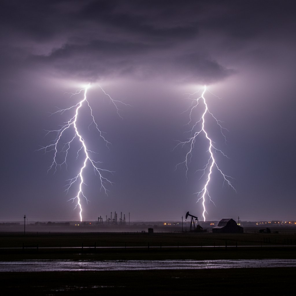
It was just another humid evening in North Texas when the sky turned into a live-wire canvas. As the sun dipped below the horizon, a slow-moving thunderstorm rolled over the Dallas-Fort Worth metroplex, turning the twilight into a strobe-lit spectacle. One resident, standing on a rural stretch just north of Denton, managed to capture a couple of lightning strikes that illuminated the entire sky—a moment that would soon become the talk of the local weather community.
The images, shared widely on social media, show branching bolts of electricity descending from a dark, churning cloud base, striking the prairie with pinpoint accuracy. For those who witnessed it, the storm was a reminder of nature’s raw power—and its unpredictability.
A Sky Alive with Electricity
Yesterday evening’s storm was part of a series of severe weather events that have been sweeping across the Southern Plains. According to the National Weather Service in Fort Worth, the storm produced frequent cloud-to-ground lightning, with some strikes exceeding 50,000 degrees Fahrenheit—hotter than the surface of the sun. The lightning was accompanied by heavy rain and gusty winds, but no major damage was reported in the immediate area.
“It was a classic pulse thunderstorm—short-lived but intense,” said Dr. Emily Torres, a meteorologist with the National Weather Service. “The combination of high instability and abundant moisture created perfect conditions for frequent lightning. We saw peak rates of over 100 strikes per hour across the region.”
The captured strikes were particularly photogenic because they occurred just after sunset, when the contrast between the dark sky and the bright bolts is most dramatic. Such moments are fleeting, and for photographers and storm chasers, they represent the holy grail of weather photography.
The Science Behind the Strikes
Lightning is a discharge of static electricity that builds up within thunderclouds. In a typical storm, ice crystals and water droplets collide, creating an electrical charge separation—positive charges accumulate at the top of the cloud, negative at the bottom. When the difference becomes too great, a lightning bolt leaps to the ground or to another cloud.
In North Texas, the geography plays a role. The flat, open terrain allows storms to develop without much obstruction, and the warm, moist air from the Gulf of Mexico provides ample fuel. “This region is part of what we call ‘Lightning Alley,’” explained Dr. Marcus Reed, a climatologist at Texas A&M University. “It’s one of the most lightning-prone areas in the United States, second only to Florida. On any given summer evening, we can expect a few good storms.”
But what made yesterday’s storm stand out was not just the lightning—it was the way the strikes were captured. The photographer, who wishes to remain anonymous, said they had been waiting for hours. “I saw the storm building around 6 p.m.,” they told a local news outlet. “By 7:30, it was right overhead. I got lucky with two good bolts in a row.”
Lightning Safety in the Lone Star State
While the images are beautiful, they serve as a stark reminder of the dangers of lightning. According to the National Lightning Safety Council, Texas consistently ranks among the top states for lightning fatalities. In 2023 alone, lightning claimed 12 lives in the state, with many of those deaths occurring during recreational activities or outdoor work.
“People often underestimate how far lightning can strike from a storm,” said Sarah Kline, a lightning safety expert with the National Weather Service. “The ‘bolt from the blue’ can travel up to 10 miles from the parent thundercloud. If you hear thunder, you are already within striking distance.”
The captured lightning in North Texas serves as a teachable moment. Meteorologists urge residents to seek shelter immediately when thunderstorms approach—ideally in a substantial building or a hard-topped vehicle. Avoid open fields, high ground, and tall objects like trees or metal fences.
“It’s tempting to stand outside and watch the show, but no photo is worth your life,” Kline added. “The moment you see a flash, count the seconds until you hear thunder. If it’s less than 30 seconds, you need to get inside.”
What This Storm Means for the Region
Yesterday’s storm is a harbinger of what’s to come. North Texas is entering its peak severe weather season, which typically runs from March through June. Climate models suggest that as global temperatures rise, the frequency and intensity of thunderstorms may increase, potentially leading to more lightning, hail, and tornadoes.
“We’re seeing a shift in storm patterns,” said Dr. Reed. “Warmer air holds more moisture, which enhances storm energy. While we can’t attribute any single event to climate change, the trend is clear—more instability means more lightning opportunities.”
For residents of North Texas, the message is to stay vigilant. The same storms that produce breathtaking lightning can also bring flash flooding, large hail, and damaging winds. The National Weather Service recommends having multiple ways to receive warnings, including NOAA weather radios and smartphone alerts.
As for the photographer, they plan to submit the images to a local weather contest. “It was a reminder of why I love living here,” they said. “The sky is always doing something interesting.”
Looking ahead, forecasters are monitoring another wave of storms expected to move into the region later this week. With the ground already saturated from recent rains, there is a heightened risk of flash flooding—and, of course, more lightning. Whether you’re a photographer, a farmer, or just someone who enjoys the spectacle, the skies over North Texas are sure to keep delivering surprises.