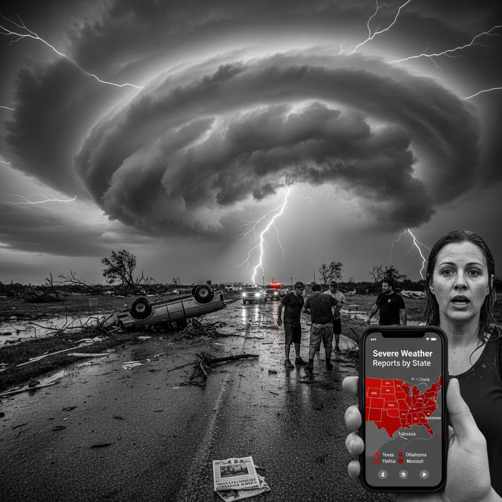
Nearly 15,000 severe weather reports—tornadoes, damaging winds, and large hail—have been logged across the United States in 2024, and just five states account for more than 40% of the total. New data from the National Oceanic and Atmospheric Administration (NOAA) and the Storm Prediction Center (SPC) reveals a concentrated belt of storm activity that stretches from the Southern Plains into the Midwest. But the rankings may surprise you.
Texas leads the nation with over 2,100 reports as of mid-October, followed by Oklahoma (1,450), Kansas (1,320), Nebraska (1,180), and Iowa (1,050). These five states have experienced a relentless parade of supercell thunderstorms, derechos, and hailstorms that have shattered local records and strained emergency management systems.
The 2024 Severe Weather Scorecard
The SPC’s preliminary severe weather database—which includes tornadoes, hail at least one inch in diameter, and thunderstorm wind gusts of 58 mph or higher—shows a 12% increase in reports compared to the 10-year average. The top five states alone have seen more combined reports than the bottom 20 states put together.
Texas, as always, is a powerhouse. Its size and geography—from the Gulf Coast to the High Plains—make it a magnet for severe storms. But the real story is the surge in activity across the central Plains. Oklahoma, for instance, recorded its second-highest number of severe hail events in a decade, with many stones exceeding 2 inches in diameter.
“What we’re seeing in 2024 is a classic La Niña influence, shifting the jet stream and creating a persistent corridor of instability from the Texas Panhandle up into Iowa,” said Dr. Emily Carver, a meteorologist at the University of Oklahoma’s School of Meteorology. “The ingredients—moisture, lift, and shear—have aligned repeatedly, leading to back-to-back outbreak days.”
Kansas and Nebraska have also seen a notable uptick. Both states experienced a rare June derecho that produced a 400-mile swath of wind damage, with gusts measured at 100 mph in some locations. Iowa, meanwhile, was hammered by a series of tornado outbreaks in May and August, including an EF-3 that carved a 30-mile path through Greene County.
Why These States Top the List
Geography and atmospheric patterns explain much of the concentration. The region known as Tornado Alley has shifted slightly eastward in recent years, but the core remains anchored in the Plains. In 2024, a persistent ridge over the western US and a trough over the east forced storm systems to ride along the boundary, repeatedly firing thunderstorms over the same areas.
But it’s not just about location. The year’s severe weather has been marked by an unusual number of nocturnal storms. Nighttime tornadoes, which are particularly dangerous because they are harder to see and catch people asleep, accounted for nearly 30% of all tornado reports in the top five states—well above the historical average of 20%.
Hail has been another standout. The number of reports of hail 2 inches or larger is up 35% compared to the 5-year mean in these states. Nebraska alone saw 18 days with hail exceeding 1.75 inches, a record. “Larger hail is a signature of intense updrafts, which we often see in a high-shear, high-CAPE environment,” explained James Hartfield, a warning coordination meteorologist at the National Weather Service in Topeka, Kansas. “This year, we had that combination more often than usual.”
The economic toll is staggering. Insured losses from severe thunderstorms in the US are on track to exceed $50 billion in 2024, according to preliminary estimates from the Insurance Information Institute. The top five states account for roughly half of that total, driven by hail damage to roofs, vehicles, and crops. In Texas, agricultural losses from hail alone are estimated at $1.2 billion.
A Changing Climate? Historical Context
Is this a sign of a long-term shift? Climate scientists are cautious but note that the data aligns with projections. Warmer temperatures increase atmospheric moisture and instability, two key ingredients for severe storms. The number of days with favorable severe weather parameters has increased by 15% in the central US since 1979, according to a 2023 study in the Journal of Climate.
However, 2024’s spike is also influenced by natural variability. The La Niña pattern that emerged in late 2023 and persisted through 2024 is known to enhance severe weather in the Plains and Midwest. Dr. Carver points out that similar La Niña years, such as 2011 and 2013, also produced high numbers of reports. “We can’t attribute any single year to climate change,” she said. “But when you look at the trend—more intense storms, larger hail, and a longer season—it fits the broader picture of a warming world.”
Historical comparisons underscore the anomaly. The last time the top five states accounted for such a high share of national reports was 2011, when Texas, Oklahoma, Kansas, Missouri, and Alabama topped the list. That year featured the infamous Super Outbreak of April 27–28, which spawned 360 tornadoes. 2024 has not had a single outbreak of that magnitude, but the cumulative frequency has been relentless.
“What’s different in 2024 is the persistence,” said Dr. Laura Chen, a climatologist at the National Center for Atmospheric Research in Boulder, Colorado. “We’re not seeing one huge event, but week after week of moderate to severe storms. That wears on communities and infrastructure in a different way.”
For residents in the top five states, the message is clear: severe weather is not just a spring and summer phenomenon anymore. The 2024 season started early with a February tornado outbreak in Texas and has continued late into October, with a recent hailstorm in Kansas on October 10. The traditional “peak season” of April through June now extends from March through October in some areas.
What This Means for Your Safety
If you live in one of the top five states—or anywhere in the central US—the 2024 data is a reminder to review your preparedness. Have multiple ways to receive warnings, including a NOAA weather radio and smartphone alerts. Know the difference between a watch and a warning, and have a safe room or basement designated. For those in mobile homes, identify a nearby shelter ahead of time.
Insurance coverage is another critical factor. Standard homeowners policies cover wind and hail damage, but deductibles for hail often differ. After a year like 2024, some insurers in Texas and Oklahoma are raising rates or non-renewing policies in high-risk areas. Check your policy and consider adding replacement-cost coverage for roofs.
Communities are also adapting. In Nebraska, several towns have installed outdoor warning sirens that can be activated remotely for nighttime storms. In Kansas, the state emergency management agency has launched a campaign to encourage “severe weather readiness kits” in every household. These steps, while small, can save lives.
Looking ahead, the 2024 severe weather season is not over yet. The La Niña pattern is expected to weaken but persist into early 2025, meaning the risk could continue through the winter months. For the top five states—and for the nation—this year’s data is a stark reminder that severe weather is becoming more frequent, more intense, and more costly. Whether this is a new normal or a temporary spike, one thing is certain: the storms are not waiting for anyone.