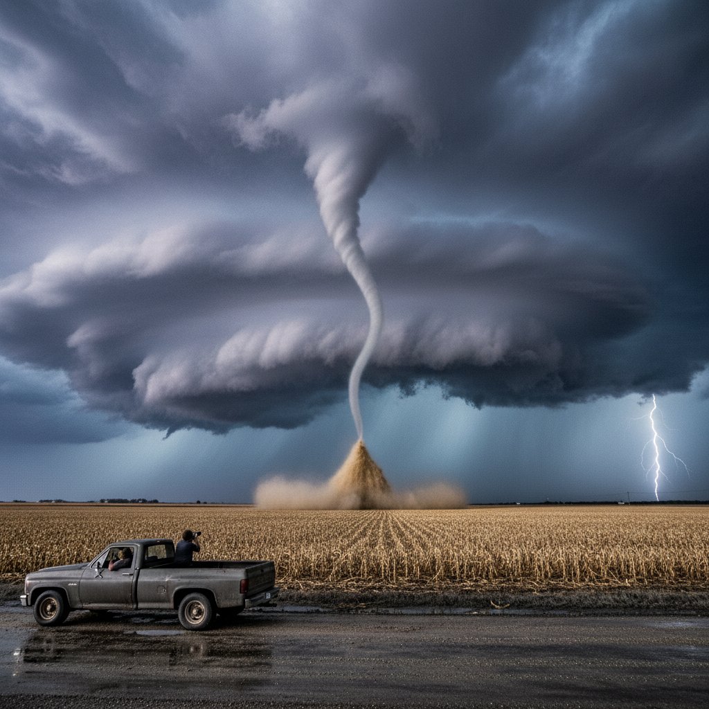
It was just after 2 p.m. on a sweltering July afternoon when a Kansas farmer looked up at the sky and saw something strange: a dark, boiling cloud descending like an invisible fist. Within minutes, a wall of wind slammed into his property, snapping century-old oaks like twigs and flipping his tractor onto its side. By the time the gust passed, the National Weather Service had logged a 78-mph microburst—a sudden, violent downdraft that left a mile-long scar of destruction. But on the local radar screen, one meteorologist called it a ‘fun little downdraft.’
The phrase, captured on a live broadcast and shared widely online, has sparked a crucial conversation about how we perceive and prepare for these overlooked yet deadly weather events. Because while microbursts may appear small on radar, their impacts are anything but fun.
The Day the Sky Fell
The incident unfolded near the town of Hays, Kansas, on July 18, 2025. Residents described a sudden roar, like a freight train, followed by a blast of air that knocked people off their feet. “I was on my porch, and it was like someone took a giant broom and swept everything away,” said local resident Martha Keene, 67. “My carport collapsed. I’ve never seen anything like it.”
First responders reported downed power lines, uprooted trees blocking roads, and a handful of minor injuries from flying debris. The storm lasted less than five minutes, but its concentrated energy was equivalent to a small, EF-0 tornado. However, unlike a tornado, a microburst leaves straight-line wind damage—a telltale pattern of flattened crops and trees all pointing in the same direction.
“The term ‘downdraft’ sounds innocuous, but when you compress that volume of air into a narrow column and slam it into the ground, it can exceed 100 mph,” explains Dr. Laura Chen, a meteorologist and severe storms researcher at the University of Oklahoma. “We’ve seen microbursts flip small aircraft, derail trains, and tear roofs off homes. They are not to be underestimated.”
Indeed, the Federal Aviation Administration has linked microbursts to at least 26 major airline incidents worldwide since 1980, most famously the 1985 crash of Delta Flight 191 at Dallas/Fort Worth. That tragedy killed 137 people and catalyzed the installation of Doppler radar at airports—but ground-level awareness remains dangerously low.
What Is a Microburst?
In meteorological terms, a microburst is a small, intense downdraft that occurs when a thunderstorm’s updraft collapses. Rain-cooled air plummets thousands of feet, hitting the surface and spreading out in all directions like water from a faucet hitting a sink. The diameter is typically less than 2.5 miles, and the lifespan is a scant 5 to 15 minutes—making them notoriously difficult to predict.
There are two types: wet microbursts, accompanied by heavy rain, and dry microbursts, which produce little to no precipitation but can stir up blinding dust. Both pack a punch. A study from the National Severe Storms Laboratory found that microbursts account for roughly 10% of all damaging wind reports in the United States each year—more than most people realize.
“What makes them so dangerous is their suddenness,” says Dr. Chen. “You might have blue skies one minute, then a tiny thunderstorm pops up, collapses, and destroys a neighborhood before anyone can take shelter. The warning time is often zero.”
In the Kansas case, Doppler radar did detect a strong reflectivity core aloft, but the microburst itself formed and dissipated before alerts could reach the public. The National Weather Service issued a Severe Thunderstorm Warning only after the event had already passed. This lag underscores a critical gap in our warning systems.
Why ‘Fun Little Downdraft’ Is Misleading
The phrase ‘fun little downdraft’ was used by a local TV meteorologist examining radar data during a lull in severe weather coverage. It was likely intended as a casual descriptor, but the clip quickly went viral, drawing criticism from storm chasers and emergency managers. “Language matters,” says Mike Thompson, a veteran storm spotter and volunteer with the Oklahoma Severe Storms Network. “Calling it ‘fun’ trivializes real damage and injuries. We need the public to take these events seriously.”
Thompson recalls a 1996 microburst in Oklahoma City that toppled a tree onto a car, killing a mother and her young daughter. “That wasn’t fun. It was tragic. And if we use words that minimize the risk, people might not react quickly enough when it really counts.”
Dr. Chen agrees, adding that as climate change amplifies thunderstorm intensity, microbursts may become more frequent. “Warmer air can hold more moisture, and more moisture means stronger downdrafts. We’re already seeing a shift in the frequency of high-wind events in some regions.” A 2023 study in the journal Geophysical Research Letters projected a 7–10% increase in severe thunderstorm wind gusts per degree of global warming.
But the real risk lies not in the statistics, but in the blind spot. Despite advances in radar, microbursts remain a nowcasting challenge—something meteorologists struggle to warn for in real time. For ordinary people, the best defense is situational awareness: watch for a sudden burst of outflow winds, a dark horizontal cloud base (known as a shelf cloud), or a shower of rain that seems to explode outward.
Staying Safe in the Age of Sudden Storms
For residents like Martha Keene, the lesson is deeply personal. She now keeps a weather radio in her kitchen, and has added a reinforced safe room to her home. “I used to think tornados were the only thing to fear,” she says. “Now I know that a little downdraft can pack a huge wallop.”
Experts recommend treating any severe thunderstorm warning as a potential microburst warning. Seek shelter in a sturdy building, away from windows, and avoid open fields, golf courses, and boating. For pilots, the message is clear: stay clear of thunderstorms by at least 20 miles—earlier than standard FAA guidelines suggest for some small aircraft.
Meanwhile, the meteorological community is exploring new tools. AI-based algorithms can now scan radar data for signature collapse patterns, potentially providing an extra 5–10 minutes of lead time. The National Weather Service plans to test a new “microburst risk” product in the Plains this spring.
As for that ‘fun little downdraft’ in Kansas—it served as an unexpected wake-up call. The video clip has been viewed over 2 million times, spawning memes but also serious discussions. The meteorologist who used the phrase later apologized on social media, acknowledging the damage and pledging to be more careful with language.
“Microbursts are nature’s hidden punches,” Dr. Chen reflects. “They don’t announce themselves with a funnel cloud, but they can be just as lethal. By better understanding and respecting them, we can save lives.”
And next time a ‘fun little downdraft’ shows up on radar, hopefully the public will see it for what it really is: a reminder that the atmosphere is never quite as calm as it looks.