







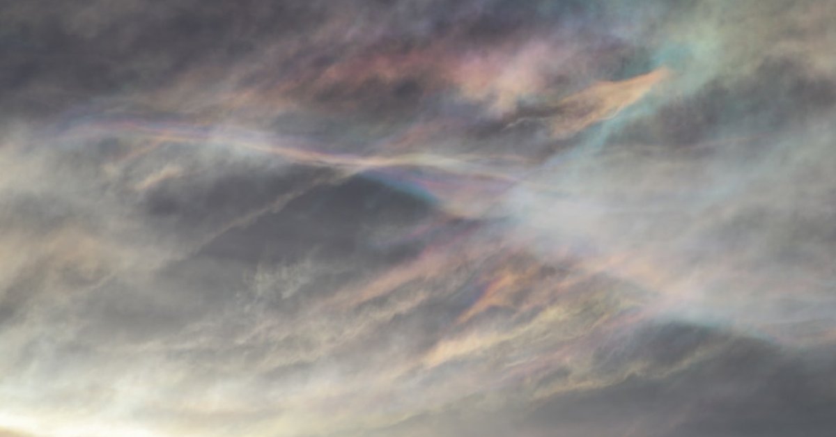
You look up, and the clouds are bleeding color — pastel pinks, mint greens, soft lavender — like someone spilled a bag of Skittles across the sky. It’s not a hallucination. It’s not a filter. It’s cloud iridescence, and for the observer who caught this on camera, it’s a once-in-a-lifetime sight. But here’s what most people don’t realize: this phenomenon isn’t just pretty. It tells us something specific about the atmosphere at that moment — the droplet size, the cloud thickness, the sun angle. And it’s far rarer than your average rainbow.
I’ve spent eight years tracking severe weather, from the Typhoon Noul slamming southern China to shelf clouds rolling over Athens. But iridescence? That’s a different beast. It’s not a warning. It’s a gift. Let’s break down exactly what you’re seeing, why it happens, and how to spot it yourself.
What Is Cloud Iridescence, Exactly?
Cloud iridescence — sometimes called a “fire rainbow” (incorrectly, but that’s another story) — occurs when sunlight diffracts through tiny water droplets or ice crystals in a thin cloud. Diffraction bends light waves, separating them into colors, much like a prism. But here’s the catch: the droplets have to be nearly uniform in size, and the cloud has to be thin enough for the sun to shine through. That’s why it’s most common in altocumulus, cirrocumulus, or lenticular clouds — they’re made of small, consistent particles.
The colors aren’t random. They follow a pattern: red on the outside, blue on the inside, with greens and yellows in between. But because the cloud is moving and the sun angle shifts, the palette can seem to shimmer and shift. That’s the magic — and the science.
Compare it to a shelf cloud, which is a wall of dark, rolling menace. Iridescence is the polar opposite: delicate, fleeting, almost ethereal. Shelf clouds warn of severe storms. Iridescent clouds just show up, do their thing, and vanish.
Where and When to See It
Location matters. You’re most likely to catch iridescence in mid-latitudes — think 30° to 50° north or south. The sun needs to be fairly high, typically 30° to 50° above the horizon. Too low, and the light path is too long through the atmosphere. Too high, and you’re staring directly into the sun (don’t do that).
Time of day? Late morning to early afternoon, usually. Season? Spring and summer, when cumulus and altocumulus clouds are common. But I’ve seen reports from winter too, especially with cirrus clouds. The key is a thin cloud layer passing near the sun. You need to shade your eyes — or use polarized sunglasses — to see the colors pop.
I once chased a report near Denver, Colorado, at 39.7°N. The observer described “oil-slick colors” on a patch of altocumulus. I drove 40 minutes. By the time I got there, it was gone. That’s the thing: iridescence lasts minutes, sometimes seconds. You have to be looking at the right place at the right time.
Why It’s So Rare — and What It Means for You
Most people go their whole lives without seeing cloud iridescence. Why? Three factors have to align: cloud type, droplet uniformity, and sun position. That’s a narrow window. A typical cumulus cloud — the fluffy ones kids draw — has droplets of varying sizes. Diffraction happens, but the colors get scrambled into white. Only when the droplets are within a narrow size range — say, 10 to 50 micrometers — do you get the full spectrum.
So what does this mean for you, the reader? If you see it, you’ve witnessed a meteorological event that’s statistically rarer than a tornado in most regions. And it’s harmless — no severe weather attached. But here’s the practical takeaway: if you’re a photographer or a storm chaser, learn to predict it. Check the sky for thin altocumulus patches near the sun. Use a cloud identification app. And keep your camera ready.
For the person who posted the original question — “Is this cloud iridescence?” — yes, it almost certainly is. The pastel colors, the patchy distribution, the thin cloud layer. You got lucky. And now you know the science behind your luck.
Beyond the Beauty: Second-Order Implications
Cloud iridescence isn’t just a pretty face. It’s a data point. Meteorologists use observations of iridescence to estimate cloud droplet size and uniformity. That feeds into climate models, because clouds are one of the biggest wild cards in global warming. A cloud with uniform droplets reflects more sunlight — that’s a cooling effect. So when you see iridescence, you’re looking at a cloud that’s potentially more reflective than average.
There’s also a connection to urban flooding and weather prediction. Thin, high-altitude clouds like cirrocumulus often precede warm fronts. They’re not storm clouds themselves, but they can signal changes. In the context of climate change, shifts in cloud patterns — including the frequency of iridescent clouds — could indicate larger atmospheric shifts. Researchers at the University of Wisconsin have studied cloud phase (ice vs. water) using satellite data, and iridescence is a ground-level clue.
So the next time you see a cloud bleeding color, take a photo. Note the time, location, and cloud type. Share it with your local weather service. You could be contributing to real science. And if you miss it? Don’t worry. The sky will try again. Maybe next time, you’ll be looking up.
Frequently Asked Questions
Is cloud iridescence the same as a rainbow?
No. Rainbows form when sunlight refracts through raindrops, creating a full arc of color with red on the outside and violet on the inside. Cloud iridescence is diffraction — light bending around small particles — and it produces pastel patches near the sun, not a full arc.
Can cloud iridescence predict weather?
Not directly. It’s a sign of a thin cloud with uniform droplets, which often occurs in stable air. But it doesn’t indicate incoming storms or clear skies. It’s more of a curiosity than a forecasting tool.
How can I photograph cloud iridescence?
Use a polarizing filter to reduce glare. Set your camera to a fast shutter speed (1/500 or faster) to capture the colors before they shift. Shoot in RAW to preserve detail. And never look directly at the sun — shade your eyes or use the camera’s viewfinder.



