







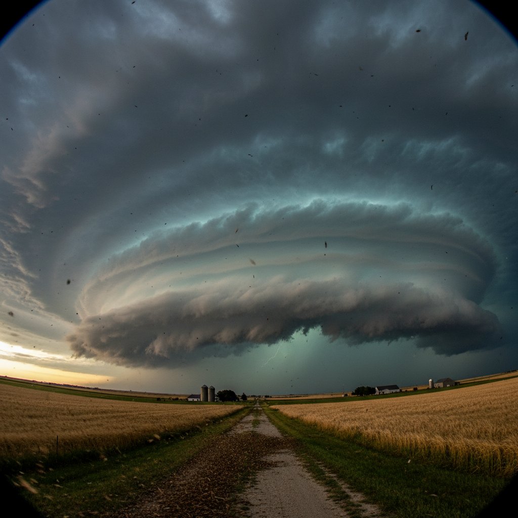
On the afternoon of May 10, 2024, a supercell thunderstorm near the town of Greensburg, Kansas, produced a wall cloud so massive and perfectly sculpted that seasoned storm chasers called it the most photogenic they had seen in years. Measuring nearly 5 miles across and rotating ominously at speeds exceeding 40 mph, the cloud hung low over the Flint Hills—a vivid reminder of the raw power lurking inside Great Plains thunderstorms.
The storm, which ultimately dropped three brief tornadoes—all rated EF-1—left a trail of snapped power poles and damaged grain silos but, remarkably, no fatalities. For the roughly 1,500 residents of Greensburg and surrounding Kiowa County, it was both a spectacle and a scare. “I’ve lived here my whole life,” said 63-year-old farmer Janet Morrison. “I’ve seen dozens of wall clouds, but this one looked like something from a movie—like the sky was about to fall on us.”
Anatomy of a Supercell
Supercells are the most dangerous type of thunderstorm, defined by a persistent rotating updraft called a mesocyclone. On this day, the atmosphere over western Kansas was primed for explosive development: surface temperatures hit 90°F, dew points climbed into the low 70s, and wind shear—the change in wind speed and direction with height—was extreme. The Storm Prediction Center had issued a Moderate Risk (level 4 of 5) for severe weather across the region.
“A supercell is like a well-oiled engine,” explained Dr. Emily Hartmann, a meteorologist at the University of Oklahoma’s Cooperative Institute for Mesoscale Meteorological Studies. “You need instability, moisture, and shear. On May 10, Kansas had all three in spades. The result was a storm that could sustain itself for hours and produce a classic, low-hanging wall cloud.” The Greensburg supercell reached a cloud top of 55,000 feet and produced hail up to 2.5 inches in diameter—the size of tennis balls—pummeling cars and shattering windows.
The Wall Cloud: Nature’s Warning
A wall cloud is a localized, lowering cloud base often attached to a supercell’s rain-free base. It forms when the updraft pulls moist, rain-cooled air into the storm, creating a condensation cloud that rotates. “A wall cloud is the single most important visual cue that a tornado could form at any moment,” said Mike Sweeney, a veteran storm chaser who filmed the event for a documentary series. “When I saw this one, I immediately knew it was time to get off the road and take cover. It was rotating like a top.” Indeed, the wall cloud persisted for 45 minutes, producing three brief touchdowns in open country. The National Weather Service issued a tornado warning for Kiowa County at 4:22 PM local time, giving residents 12 minutes of lead time—within the national average but still precious.
Wall clouds are not rare in the Plains, but the size and structure of the Greensburg cloud—what chasers call a “mothership”—captured national attention. Social media erupted with images and videos, some viewed millions of times within hours. “It’s a double-edged sword,” Dr. Hartmann noted. “These images raise awareness of how tornadoes form, but they can also lull people into thinking that any wall cloud will produce a tornado. Only about 20 to 30 percent actually do, but you should always treat them as if they will.”
Human Stories from the Storm
Beyond the spectacle, the storm had real consequences. Power was knocked out for more than 2,500 customers, and downed trees blocked several rural roads. The three tornadoes—each on the ground for less than 10 minutes—destroyed two empty farmhouses and severely damaged a hog confinement facility, killing dozens of animals. For Morrison, whose family has farmed the same quarter-section since 1952, the storm was a financial blow. “We lost about 10% of our wheat to hail,” she said. “Insurance will cover some, but every time this happens, it sets us back a year.”
Kansas is no stranger to severe weather. The state averages more than 60 tornadoes per year, and Greensburg itself was devastated by a massive EF-5 tornado in 2007 that killed 11 people and destroyed 95% of the town. “That memory never fades,” said Morrison. “Every time a wall cloud shows up, my heart races. You can’t help but think, ‘Is this the big one again?’” The 2024 storm stayed in open country, sparing the rebuilt town. But the psychological toll remains.
First responders from Kiowa County Emergency Management worked through the night to clear roads and check on isolated residents. “We always hope for the best but prepare for the worst,” said coordinator Lisa Tran. “This storm reminded everyone that even a weak tornado can be deadly if you’re not ready.” The county’s early-warning sirens sounded, and most residents had cellphone alerts. Still, several people reported not hearing the sirens due to high winds.
What This Means for Plains Residents
As the 2024 severe weather season continues—already one of the most active in the past decade with over 800 preliminary tornado reports nationwide—the Greensburg supercell serves as a stark warning. Climate models suggest that as the atmosphere warms, supercell environments may become more common, particularly in the southern and central Plains. “We’re seeing more days with high CAPE (convective available potential energy) and strong shear,” Dr. Hartmann said. “The ingredients for violent storms are becoming easier to assemble. The challenge is communicating risk without inciting panic.”
For storm trackers like Sweeney, the work never stops. “Every wall cloud is a lesson,” he said. “We need to keep documenting, keep educating. The public’s understanding of these storms is the difference between life and death.” Meanwhile, Morrison and her neighbors are already watching the next set of radar echoes moving in from Colorado. “You can’t stop the weather,” she said, “but you can respect it. That wall cloud—beautiful as it was—still scares me. It should scare everyone.” The storm may have passed, but the conversation it sparked about preparedness, climate change, and the awe-inspiring power of nature is only just beginning.



