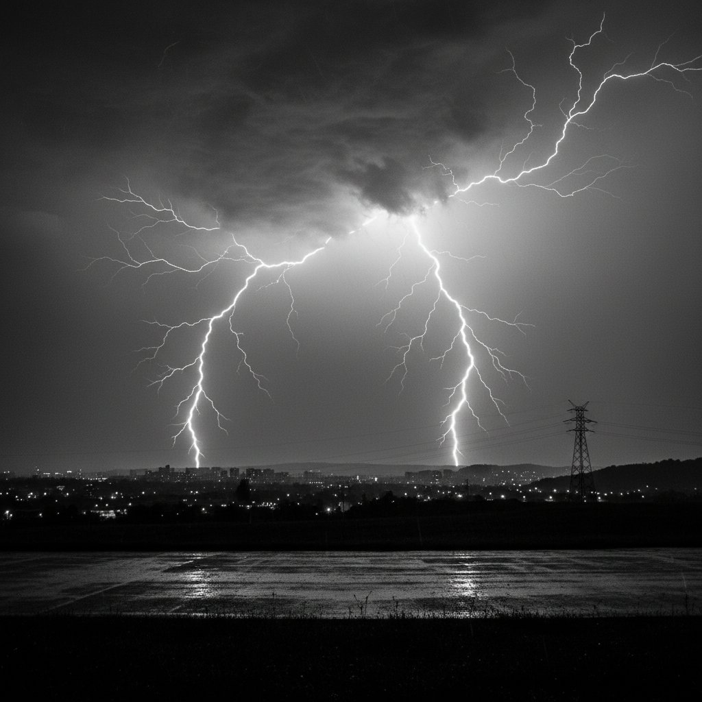
The clock had just struck 12:45 AM when the first massive bolt split the sky over central Kansas. Within seconds, a barrage of cloud-to-ground strikes followed, turning night into a staccato day. This was no ordinary overnight storm—it was a lightning supercell, packing 1,200 strikes in just 15 minutes across a 40-mile corridor from Russell to Salina.
For residents jolted from sleep, the experience was visceral. The thunderclaps arrived almost simultaneously with the flashes, indicating strikes within a mile or less. Power flickered across three counties as the electrical grid struggled to handle the surge. At its peak, the storm produced 80 strikes per minute—a rate typically seen in only the most intense convective outbreaks.
Anatomy of the Midnight Lightning Storm
Meteorologists at the Storm Prediction Center had issued a severe thunderstorm watch at 11:00 PM, but the intensity caught many off guard. The storm developed along a dryline draped from the Oklahoma Panhandle into south-central Nebraska. By midnight, a series of discrete supercells had formed, feeding on unstable air with CAPE values exceeding 4,000 J/kg—a classic setup for prolific lightning.
Data from the National Lightning Detection Network shows the strike density reached 12 strikes per square mile over a 10-minute window. The most intense activity occurred between 12:45 AM and 1:00 AM, centered near 38.8°N, 98.3°W, just northwest of Salina. Radar imagery revealed a reflectivity core of 65 dBZ, with hail signatures up to 1.75 inches in diameter embedded within the storm.
“This was a textbook nocturnal lightning event. The combination of strong low-level jet, high instability, and deep-layer shear created a sustained electrical factory. We don’t see 80 strikes per minute often outside of major squall lines.”
The storm traveled at 35 mph, tracking southeast along the I-135 corridor. Residents in McPherson County reported the sky appearing “white” for several seconds, as consecutive flashes merged into an almost continuous glow. This phenomenon, known as “flashing” or “firework lightning,” occurs when strike rates exceed the eye’s ability to perceive individual bolts—typically above 30 strikes per minute.
Historical Context and Frequency
While lightning storms are common across the Great Plains, the 12:45 AM event stands out for its timing and efficiency. Overnight storms typically produce less lightning than daytime convection, due to weaker updrafts after sunset. However, when a nocturnal low-level jet strengthens after midnight—often reaching 40-50 knots at 850 hPa—it can sustain charge separation within clouds.
In this case, the jet peaked at 52 knots near 5,000 feet, feeding warm, moist air into the storm’s updraft. The result was an electrical generator that operated for over two hours, with total strike counts exceeding 8,000 cloud-to-ground flashes across the region. To put that in perspective: an average summer thunderstorm produces 1,000 to 5,000 total lightning events. This storm packed nearly double that in a fraction of the time.
Historical records show that between 2013 and 2023, only 12% of severe thunderstorm warnings in Kansas were issued overnight. Of those, less than 4% involved lightning rates above 60 strikes per minute. The 12:45 AM storm thus falls into a rare category—one that demands heightened awareness for nocturnal severe weather preparedness.
Impact on Communities and Infrastructure
The immediate effects were widespread. More than 14,000 customers lost power across Lincoln, Ellsworth, and Saline counties. The lightning strikes caused transformer explosions in at least five substations, as documented by Evergy’s outage mapping. Emergency services reported 22 lightning-related fire calls, including a grain elevator fire near Wilson, Kansas, that took two hours to contain.
For residents, the danger extended beyond the storm itself. Lightning can travel through plumbing and electrical wiring, posing risks even indoors. The National Weather Service in Wichita issued a lightning safety statement urging people to stay off corded electronics and avoid running water. In the aftermath, three minor injuries were reported—two from falls during the sudden darkness and one from a surge-related appliance failure.
“People often underestimate overnight lightning storms. You’re asleep, you’re vulnerable. This event underscores why we recommend having multiple ways to receive warnings, even at 1 AM.”
Agriculture also took a hit. Livestock producers in the area reported at least nine cattle deaths from lightning strikes, concentrated in open pastures near Minneapolis, Kansas. The economic loss from damaged equipment and livestock is preliminarily estimated at $2.1 million, according to the Kansas Department of Agriculture.
Forecast and Safety Recommendations
Looking ahead, the pattern remains active. The same low-level jet will shift eastward into Missouri and Iowa by the following evening, with the Storm Prediction Center indicating a slight risk of severe thunderstorms for a 150-mile swath from Kansas City to Des Moines. Lightning rates may again approach 50-60 strikes per minute, though the exact timing remains uncertain.
For residents in the affected area, recovery continues. Power restoration is expected to take 24-48 hours in rural stretches. The Federal Emergency Management Agency has not issued a disaster declaration, but county officials are assessing damage for possible federal assistance. In the meantime, the best defense against future nocturnal lightning events is preparation: install surge protectors, keep flashlights accessible, and ensure weather radios are programmed to wake you for warnings.
What this means for you: If you live in the central or southern Plains, overnight lightning storms like this one are a reminder that severe weather does not follow a 9-to-5 schedule. The 12:45 AM event was a statistical outlier, but with climate patterns shifting, such outbreaks may become more common. Stay weather-aware, even when the rest of the world sleeps.