In late May, the Netherlands experienced its earliest 30°C (86°F) day on record, with the mercury hitting 30.6°C at the De Bilt weather station on May 27. Outdoor cafés overflowed, canals brimmed with boats, and farmers scrambled to irrigate parched fields. But just days later, a dramatic shift swept across the country: June arrived with a biting chill, as daytime highs plunged to 12°C (54°F) — a drop of nearly 19 degrees in less than a week. This whiplash of extremes has left residents, farmers, and meteorologists grappling with what may be a new normal for the Dutch summer.
A Record-Breaking Prelude to Summer
The late-May heat wave was nothing short of historic. According to the Royal Netherlands Meteorological Institute (KNMI), the 30.6°C reading at De Bilt on May 27 broke the previous record for the earliest 30-degree day in the country’s 120-year modern observational history. The old record, set on May 28, 2018, was 30.0°C. In Maastricht, temperatures soared to 31.2°C, while Eindhoven and Tilburg also topped 30°C.
“To see such intense heat so early in the season is remarkable,” said Maria Jansen, a spokesperson for the KNMI. “We typically see the first 30-degree day in late June or early July. This was a full month ahead of schedule.”
The warmth triggered an early start to the outdoor season. Beach towns like Zandvoort reported near-capacity crowds, and Amsterdam’s Vondelpark was packed with sunbathers. Yet beneath the surface, concerns were mounting. “My strawberry crop started flowering two weeks early,” said Dirk van der Heijden, a farmer in the Flevoland province. “Then the cold hit, and I lost nearly a third of the blossoms to frost damage. It’s a gamble every year, but this swing was brutal.”
The Sudden Shift: Why June Turned Cool
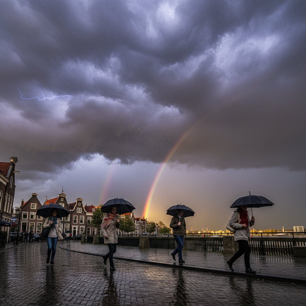
The abrupt transition from heat to chill was driven by a dramatic reorganization of the jet stream. During the last week of May, a strong ridge of high pressure over western Europe pulled warm air from the Sahara into the Netherlands. But by June 1, that ridge collapsed, allowing a deep trough of low pressure to dig south from the Arctic. Cold air from the North Sea and Scandinavia flooded the region, bringing overcast skies, persistent drizzle, and temperatures more typical of early April.
“This kind of pattern flip is not unusual in spring, but the magnitude of the change was extreme,” explained Dr. Jan van der Meer, a climatologist at Wageningen University. “The jet stream has been unusually wavy this year, a pattern that some studies link to Arctic amplification and a weakening of the polar vortex. While we cannot directly attribute this single event to climate change, it fits the expectation of more frequent and intense weather swings.”
The shift was felt across the country. In Groningen, June 2 recorded a high of just 11.8°C, the coldest June day since 1991. Snow even dusted the highest peaks of the Vaalserberg, though it melted within hours. The KNMI issued a warning for unseasonably cold temperatures, advising farmers to protect sensitive crops.
Human and Economic Toll
The whiplash has had real consequences. For farmers like van der Heijden, the sudden cold after the early heat caused “frost shock” in fruit trees and vegetables. The Dutch agriculture sector, already facing pressure from rising costs and nitrogen regulations, now faces potential losses in the millions. “Apples, pears, cherries — all were in a vulnerable stage,” said van der Heijden. “We covered what we could with fleece, but you can’t protect entire orchards.”
Small businesses also took a hit. “We invested in extra patio furniture and hired seasonal staff a week early because of the warm weather,” said Emma de Wit, owner of a café in Utrecht. “Then the cold came and nobody wanted to sit outside. Our revenue dropped by 40% compared to last June.”
Energy demand swung wildly. During the heat wave, air conditioning usage surged — a rare occurrence in a country where fewer than 20% of homes have AC. Then, with the cold snap, heating systems kicked back on. “It’s like we went from summer to winter in a week,” said Jansen. “That puts stress on the grid, especially as renewables like solar see big fluctuations.”
What This Means for the Rest of Summer
While the immediate forecast shows a gradual warming trend toward seasonal norms by mid-June, the question on many minds is whether this pattern signals a volatile summer ahead. Long-range models from the European Centre for Medium-Range Weather Forecasts (ECMWF) suggest a weak El Niño transition in the Pacific, which often amplifies jet stream meanders over Europe. “We could see more of these oscillations — heat spikes followed by cool, wet periods,” warned van der Meer.
For residents, the advice is to stay flexible. “We’re telling people not to pack away their sweaters just yet,” said Jansen. “And for those planning summer festivals or outdoor events, have a contingency plan.” The KNMI plans to update its seasonal outlook in mid-June, incorporating the latest ocean and atmospheric data.
As the Netherlands navigates this early-season weather rollercoaster, one thing is clear: the old certainties of a gradual warm-up are fading. “We used to joke that Dutch summers start on July 1,” said van der Heijden, shaking his head. “Now I’m not sure when they’ll start — or if they’ll stay.”
The coming weeks will test the resilience of a nation long accustomed to mild, predictable summers. With climate models pointing toward increased variability, the Dutch may need to adapt not just to heat, but to the whiplash that follows.