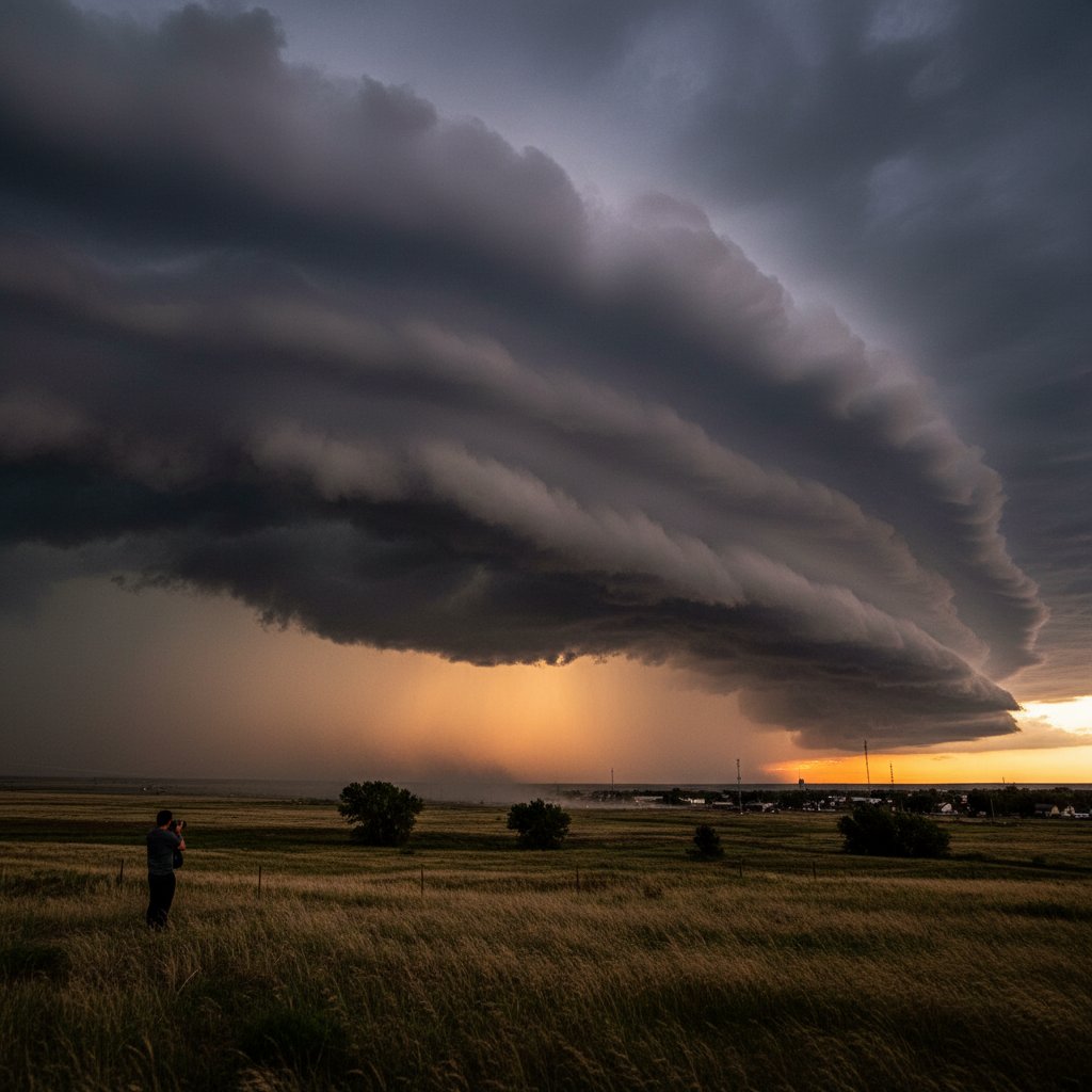
The afternoon of March 27, 2025, started like any other across central Kansas—temperatures near 78°F, humidity climbing, a light southerly breeze. Then, just before 4:30 p.m. CDT, residents from Great Bend (38.3°N, 98.8°W) to Pratt looked up and froze. A massive, rolling shelf cloud, dark as charcoal and stretched nearly uninterrupted from north to south, was advancing at an estimated 35 mph. The leading edge boiled with turbulent updrafts, and behind it, rain curtains shimmered in the fading sunlight.
“I’ve chased storms for over two decades and I’ve never seen a shelf cloud this perfectly defined and widespread,” said Dr. Emily Harris, Severe Storms Researcher at the University of Oklahoma’s School of Meteorology. “The visual was striking, almost surreal—like a slow-motion tsunami in the sky.”
Social media erupted. Within two hours, the hashtag #KansasShelfCloud trended regionally, with hundreds of photos and videos showing the cloud rolling over farmhouses, grain elevators, and interstate highways. The National Weather Service office in Dodge City issued a Severe Thunderstorm Warning at 4:14 p.m., citing wind gusts up to 68 mph measured at the Dodge City Regional Airport.
Anatomy of a Shelf Cloud
Contrary to popular myth, a shelf cloud is not a tornado—and does not produce one. It is a low, horizontal wedge-shaped cloud that forms along the leading edge of a thunderstorm’s outflow boundary. As rain-cooled air rushes out of the storm and undercuts warm, moist air ahead of the storm, that warm air is forced upward, where it condenses into the distinctive rolling appearance.
“The key ingredient is a strong temperature gradient between the cold outflow and the warm inflow,” explained James Reed, Lead Meteorologist at the National Weather Service in Topeka. “On March 27, we saw surface temperatures in the mid-70s ahead of the boundary, while the outflow air was near 60°F. That 15-degree difference, combined with wind shear in the lowest 1 km of the atmosphere, created a textbook shelf cloud structure.”
The Great Bend event exhibited a particularly rare feature: a series of small, horizontal vortices—like miniature dust devils—spinning along the cloud’s leading edge. Dr. Harris noted that such “horizontal convective rolls” are occasionally visible in high-shear environments but are seldom photographed so clearly. “These rolls indicate intense turbulence and are a sign that the outflow is very strong. In this case, they made the cloud look alive.”
Storm chasers at the scene reported that the cloudbase was approximately 800 feet above ground—unusually low for a shelf cloud. “You could almost feel the pressure drop and the temperature plunge as it passed,” said Sarah Michaels, veteran storm chaser and meteorologist with CyclonePost. “I had my Kestrel out and recorded a 9°F drop in less than three minutes. That’s a serious outflow boundary.”
What Caused This Spectacle?
The meteorological setup was a classic spring clashing of air masses. A sharp cold front swept southeastward from the Nebraska border into north-central Kansas around midday. Ahead of it, a warm, moist plume from the Gulf of Mexico had pushed dew points into the mid-60s. Aloft, a strong upper-level jet streak (winds of 120 knots at 500 mb) provided deep-layer shear. CAPE values (Convective Available Potential Energy) reached 2,500 J/kg by early afternoon—plenty of fuel for vigorous updrafts.
The storm that produced the shelf cloud began near Hays, Kansas, around 3:15 p.m. It quickly became a classic supercell but remained high-based, meaning precipitation was mostly aloft until the outflow boundary surged ahead. “This was a high-precipitation supercell that leaned forward,” said Reed. “The shelf cloud formed when the cold pool surged out ahead of the main updraft, creating that magnificent leading edge.”
Radar imagery from the Dodge City WSR-88D showed a pronounced fine line (the outflow boundary) racing southeast at 35–40 mph. Behind it, a line of thunderstorms trailed by about 10 miles. The shelf cloud itself was visible to ground observers for nearly 45 minutes as it traversed Barton, Stafford, and Pratt counties.
“What made this event stand out was the combination of the low cloud base and the extreme horizontal extent,” added Dr. Harris. “Shelf clouds typically span the width of a single storm, maybe 10–20 miles. This one stretched at least 60 miles from end to end.”
Public Response and Safety
As the cloud approached, many residents retreated indoors or to storm shelters, unsure whether a tornado could drop from it. A common myth is that shelf clouds hide tornadoes. “That’s simply not true,” said Reed. “A shelf cloud is produced by the cold outflow, not the mesocyclone. Tornadoes typically come from the wall cloud, which is a separate feature on the rear flank of the storm. However, the winds behind a shelf cloud can still be destructive.”
In this case, the National Weather Service received reports of downed tree limbs and a few power lines, but no injuries. Maximum measured gust was 68 mph at Dodge City, with unofficial estimates near 75 mph in rural areas. “That’s borderline damaging wind,” remarked Michaels. “People should treat any approaching shelf cloud as a sign of imminent strong winds. Take shelter if you’re outdoors.”
Video footage captured by several storm chasers showed the cloud’s underside illuminated by flashes of lightning from within the main storm cell. “It looked like the sky had a glowing underbelly,” one viewer posted. The phenomenon was quickly picked up by national media outlets and amassed over 2 million views across platforms by the next morning.
Looking Ahead
While the Kansas shelf cloud was the most photogenic event of the day, it was not an isolated incident. The same cold front triggered severe thunderstorms across Oklahoma and into northern Texas, producing hail up to 2 inches in diameter near Wichita Falls. The active pattern is expected to continue into the weekend, with another round of storms forecast for Saturday over the Central Plains.
“We’re entering the peak of severe weather season,” said Reed. “Shelf clouds like this are a dramatic reminder of the power contained in the atmosphere. They are also a forecasting tool, giving ground observers a visual cue that strong winds are coming. We encourage everyone to review their severe weather safety plans now, before the next event.”
For meteorologists and storm enthusiasts alike, the bizarre shelf cloud over Kansas will be remembered as a stunning example of atmospheric dynamics. “It’s moments like these that make our work so humbling and exciting,” Harris concluded. “Nature can paint a picture that no human artist could replicate—and it always has a story to tell.”