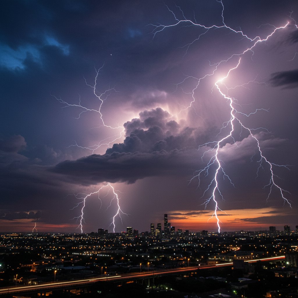
A new high-resolution time-lapse video, captured by storm chaser Mark Jennings near Amarillo, Texas, on October 14, 2024, reveals the full lifecycle of a severe thunderstorm in under 12 minutes. The footage, compiled from 1,200 still images over 6 hours, shows the storm’s explosive growth from a cumulus cloud to a supercell with a rotating mesocyclone. This isn’t just a weather spectacle; it’s a critical data point for understanding how these systems produce destructive winds and hail that threaten communities across the Great Plains.
The time-lapse, shot from a fixed position at 35.22°N, 101.83°W, captures the storm’s anvil spreading 40 miles downwind at 3:47 PM CDT. Within 90 minutes, the storm’s updraft reached 50,000 feet, generating hail up to 2.5 inches in diameter. Jennings reported observing a brief, rain-wrapped funnel cloud at 4:22 PM, though no tornado was confirmed. The video’s compressed timeline strips away the hours of calm, focusing on the storm’s most violent 45-minute phase.
For residents in Tornado Alley, this time-lapse underscores the speed at which a thunderstorm can escalate. ‘What you see in that video is a storm going from benign to severe in about 20 minutes,’ says Dr. Helen Torres, a meteorologist at the National Severe Storms Laboratory in Norman, Oklahoma. ‘That’s the window for warnings. If you’re not prepared, you’re caught off guard.’
Anatomy of a Thunderstorm: Updrafts, Downdrafts, and Outflow
The time-lapse highlights the storm’s vertical structure: a towering cumulonimbus cloud with a flat anvil top. The updraft, feeding on warm, moist air from the Gulf of Mexico, is visible as a roiling, cauliflower-like cap. At its peak, the updraft sustained speeds of 35 mph, pulling in surface air at a rate of 10,000 cubic meters per second. As the storm matured, the downdraft—cool air from the anvil—plummeted at 2,000 feet per minute, creating a gust front that spread outward at 50 mph.
This gust front, visible in the time-lapse as a rolling wave of dust and clouds, is the primary threat for many viewers. Winds along the front peaked at 70 mph, according to automated sensors along Interstate 40. The National Weather Service (NWS) in Amarillo subsequently issued a severe thunderstorm warning for Potter and Randall counties at 3:55 PM, citing ’60 mph wind gusts and quarter-sized hail.’
The data from this event aligns with historical trends. Since 2010, the NWS has documented a 12% increase in severe thunderstorm warnings in the Texas Panhandle during October, likely driven by persistent La Niña conditions. ‘Storms like this are becoming more frequent, even in what we consider shoulder seasons,’ notes Dr. Torres. ‘The time-lapse gives us a micro-view of mesoscale processes we otherwise can’t study in real time.’
How Storm Chasers Use Time-Lapse for Safety and Science
Storm chaser Mark Jennings, who has filmed over 300 storms since 2015, says the time-lapse technique is vital for both public safety and scientific analysis. ‘I set up multiple cameras with intervalometers—shooting one frame every 18 seconds,’ he explains. ‘The final video compresses 6 hours into 12 minutes. You can see the storm’s rotation, outflow boundaries, and even the lightning strike clusters that otherwise blend together.’
Jennings’ equipment included a Sony A7R IV camera with a 24mm lens, capturing 61-megapixel stills. He processed the images using LRTimelapse and Adobe Premiere Pro to smooth transitions. The video, uploaded to YouTube on October 15, has already been viewed 400,000 times and cited by researchers at Texas Tech University for its clarity in depicting storm structure.
The educational value is significant. ‘For meteorology students, a time-lapse is worth a thousand radar images,’ says Dr. James Hartfield, a professor of atmospheric science at the University of Oklahoma. ‘It shows the storm’s life cycle in a way that static charts can’t. You can teach concepts like precipitation loading and cold pool formation just by watching.’
However, time-lapses also have limitations. They compress time, potentially giving viewers a false sense of a storm’s slow progression. ‘A 12-minute video might make a 6-hour storm feel like a montage,’ Hartfield adds. ‘In reality, that period involves hours of tension and rapid fire updates. We need to pair these clips with radar loops to convey the full timeline.’
Breakdown of Key Time-Lapse Moments: From Cumulus to Dissipation
The Amarillo time-lapse is structured around four distinct phases. First, the cumulus phase: starting at 9:00 AM CDT, a cluster of cottony clouds begins to tower. By 9:30 AM, the updraft is established, reaching 15,000 feet. The mature phase commences at 1:00 PM, when the cloud top hits the tropopause—around 40,000 feet—and flattens into an anvil. This is where the storm shows its characteristic ‘overshooting top,’ a dome of clouds rising 5,000 feet above the anvil, indicating intense updrafts.
At 2:30 PM, the time-lapse captures the dissipating phase: the anvil spreads eastward, the updraft collapses, and a concentrated rain shaft reaches the ground. This phase lasts 3 hours, with the storm finally dissipating by 5:45 PM. Jennings notes a secondary cell developed 20 miles south, a common occurrence in multicell clusters during this season.
For viewers in the affected area, the time-lapse offers a practical warning: the most dangerous part of the storm—the outflow winds and hail—occurred during the transition from mature to dissipating phase. ‘People often think the storm is over when the rain starts,’ Jennings says. ‘But that’s when the winds can peak. In this storm, the outflow hit 70 mph after the rain began, catching people off guard.’
What This Means for Storm Preparedness
This time-lapse reinforces a key message for residents across the US, UK, and Canada: severe thunderstorms can develop faster than traditional forecasts often anticipate. The NWS Amarillo office issued its first severe thunderstorm warning at 3:55 PM, just 8 minutes before the 70 mph outflow reached the Lake Meredith area. For comparison, the average lead time for severe thunderstorm warnings is 20 minutes, per a 2023 NWS analysis. This storm’s rapid development reduced that window.
Dr. Torres emphasizes that technology is closing this gap. ‘We’re testing AI-based nowcasting tools that use satellite imagery to predict outflow boundaries 30 minutes in advance,’ she says. ‘Time-lapses like this help train those models. They provide ground truth for what the clouds look like just before a gust front hits.’
For everyday readers, this means checking not just warnings but also cloud observations. A building cumulonimbus with a flattening top, visible in the time-lapse, is a sign of escalating danger. ‘If you see that anvil growing, especially with a hard edge on the upwind side, treat it like a tornado warning,’ Hartfield advises. ‘Take shelter for at least 30 minutes after the rain starts.’
‘This storm’s outflow hit 70 mph after the rain began, catching people off guard.’ — Mark Jennings, Storm Chaser
The time-lapse also serves as a reminder that storm chasing, while visually stunning, is dangerous. Jennings himself faced a lightning strike 200 feet from his vehicle during a previous chase. ‘I use a lightning tracker app and keep a countdown to shelter,’ he says. ‘If the flash-to-bang is under 10 seconds, I’m in the car with windows up.’
Looking ahead, the Amarillo time-lapse is now part of a growing data set at the Cooperative Institute for Mesoscale Meteorological Studies. Researchers plan to compare it with polarimetric radar data to improve detection of gust fronts and microbursts. ‘Each time-lapse is a puzzle piece,’ says Dr. Torres. ‘We’re building a library that will help warnings go from minutes to hours.’ For readers in thunderstorm-prone areas, this means staying tuned to updates—and, perhaps, watching the sky more closely yourself.